
Allier (river)
| Allier Alèir (Occitan) | |
|---|---|
 Bridge over the Allier | |
 Map of the Allier in France [1] | |
| Location | |
| Country | France |
| Physical characteristics | |
| Source | |
| - location | Massif Central |
| - elevation | 1,503 m (4,931 ft) |
| Mouth | |
| - location | Loire |
| - coordinates | 46°57′34″N 3°4′44″E / 46.95944°N 3.07889°E |
| Length | 421 km (262 mi) |
| Basin size | 14,350 km2 (5,540 sq mi) |
| Discharge | |
| - average | 140 m3/s (4,900 cu ft/s) |
| Basin features | |
| Progression | Loire→ Atlantic Ocean |
The Allier (Occitan: Alèir) is a river in central France, left tributary of the Loire River. It flows through several regions.
The Allier department is named after this river. In Ancient Rome, the river was named Elaver.
Geography[change | change source]
The Allier river has a length of 420.7 km (261.4 mi) and a drainage basin with an area of 14,310 km2 (5,525 sq mi).[1]
Its average yearly discharge (volume of water which passes through a section of the river per unit of time) is 143.0 m3/s (5,050 cu ft/s) at Cuffy in the Cher department.[2]
 |
| Average monthly discharge (m3/s) at Cuffy (1955 - 2017)[2] |
Course[change | change source]

The source of the Allier is in the mountainous region of Margeride, part of the Massif Central, on the mountain Moure de la Gardille in the Chasseradès municipality, Lozère department. The source is at an altitude of about 1,430 m (4,692 ft).[3]
The Allier flows, in general, to the north and passes through the following regions, departments and communes:[1]
- Occitanie region
- Auvergne-Rhône-Alpes region
- Ardèche: the river forms the border between this department and Lozère.
- Haute-Loire: Alleyras, Auzon, Brioude, Langeac, Lavoûte-Chilhac
- Puy-de-Dôme: Brassac-les-Mines, Auzat-la-Combelle, Issoire, Coudes, Cournon-d'Auvergne, Pont-du-Château
- Allier: Vichy, Varennes-sur-Allier, Moulins
- Bourgogne-Franche-Comté
- Centre-Val de Loire
Finally, it flows, as a left tributary into the Loire river at the bec d'Allier ("beak of the Allier"),[N 1] near the city of Nevers, in the limits between the Cher and Nièvre departments in the towns of Marzy, Cuffy and Gimouille, at 167 m (548 ft) of altitude.[4]
Main tributaries[change | change source]
The main tributaries, with a length greater than 40 km (25 mi), of the Allier are:
|
Left tributaries:
|
|
Right tributaries: |
Gallery[change | change source]
-
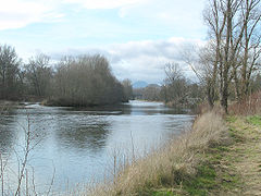 The Allier river near Pont-du-Château.
 -
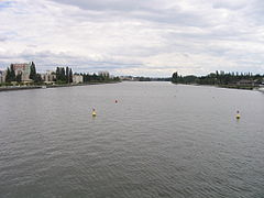 The Allier at Vichy.
 -
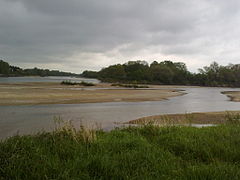
 The Allier river.
 -


.jpg)
Related pages[change | change source]
Notes[change | change source]
- ↑ The French word bec (beak or bill in English) means, in this and similar cases, the confluence of two rivers.
References[change | change source]
- ↑ 1.0 1.1 "l'Allier (K---0080)" (in French). SANDRE - Portail national d'accès aux référentiels sur l'eau. Archived from the original on 3 March 2016. Retrieved 18 December 2014.
- ↑ 2.0 2.1 "L'Allier à Cuffy [Pont du Guétin]" (in French). Banque Hydro. Archived from the original on 26 May 2016. Retrieved 15 June 2017.
- ↑ "Source de l'Allier" (in French). Géoportail. Retrieved 18 December 2014.
- ↑ "Confluence de l'Allier" (in French). Géoportail. Retrieved 18 December 2014.
- ↑ "Fiche cours d'eau: Le Chapeauroux (K21-0300)" (in French). SANDRE - Portail national d'accès aux référentiels sur l'eau. Archived from the original on 28 May 2014. Retrieved 18 December 2014.
- ↑ "Fiche cours d'eau: l'Ance (K22-030A)" (in French). SANDRE - Portail national d'accès aux référentiels sur l'eau. Archived from the original on 5 March 2016. Retrieved 18 December 2014.
- ↑ "Fiche cours d'eau: l'Alagnon (K25-0300)" (in French). SANDRE - Portail national d'accès aux référentiels sur l'eau. Archived from the original on 28 May 2014. Retrieved 18 December 2014.
- ↑ "Fiche cours d'eau: la Couze Pavin (K265400A)" (in French). SANDRE - Portail national d'accès aux référentiels sur l'eau. Retrieved 18 December 2014.[permanent dead link]
- ↑ "Fiche cours d'eau: la Morge (K27-0300)" (in French). SANDRE - Portail national d'accès aux référentiels sur l'eau. Archived from the original on 4 March 2016. Retrieved 18 December 2014.
- ↑ "Fiche cours d'eau: l'Andelot (K31-030A)" (in French). SANDRE - Portail national d'accès aux référentiels sur l'eau. Archived from the original on 4 March 2016. Retrieved 18 December 2014.
- ↑ "Fiche cours d'eau: la Sioule (K3--0200)" (in French). SANDRE - Portail national d'accès aux référentiels sur l'eau. Archived from the original on 3 March 2016. Retrieved 18 December 2014.
- ↑ "Fiche cours d'eau: la Senouire (K23-0300)" (in French). SANDRE - Portail national d'accès aux référentiels sur l'eau. Archived from the original on 28 May 2014. Retrieved 18 December 2014.
- ↑ "Fiche cours d'eau: la Dore (K2--0190)" (in French). SANDRE - Portail national d'accès aux référentiels sur l'eau. Archived from the original on 28 May 2014. Retrieved 18 December 2014.
- ↑ "Fiche cours d'eau: le Sichon (K30-0310)" (in French). SANDRE - Portail national d'accès aux référentiels sur l'eau. Archived from the original on 3 October 2015. Retrieved 18 December 2014.
Other websites[change | change source]
- Banque Hydro - Station K3650810 - L'Allier à Cuffy (Synthèse) Archived 2015-02-19 at the Wayback Machine (in French)
- The river Allier - Loire Nature