Alligator, Mississippi
Alligator, Mississippi | |
|---|---|
 | |
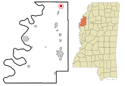
 Location of Alligator, Mississippi | |
| Coordinates: 34°5′19″N 90°43′14″W / 34.08861°N 90.72056°W[1] | |
| Country | United States |
| State | Mississippi |
| County | Bolivar |
| Area | |
| • Total | 1.04 sq mi (2.70 km2) |
| • Land | 0.98 sq mi (2.55 km2) |
| • Water | 0.06 sq mi (0.15 km2) |
| Elevation | 157 ft (48 m) |
| Population | |
| • Total | 116 |
| • Density | 117.77/sq mi (45.47/km2) |
| Time zone | UTC-6 (Central (CST)) |
| • Summer (DST) | UTC-5 (CDT) |
| ZIP code | 38720 |
| Area code | 662 |
| FIPS code | 28-00940 |
| GNIS feature ID | 0666222 |
Alligator is a town in Bolivar County, Mississippi, United States. The population was 116 at the 2020 census.[3]
References[change | change source]
- ↑ "US Gazetteer files: 2010, 2000, and 1990". United States Census Bureau. 2011-02-12. Retrieved 2011-04-23.
- ↑ "2020 U.S. Gazetteer Files". United States Census Bureau. Retrieved July 24, 2022.
- ↑ 3.0 3.1 "Profile of General Population and Housing Characteristics: 2020 Demographic Profile Data (DP-1): Alligator town, Mississippi". United States Census Bureau. Retrieved February 10, 2024.


