
Ambert
Ambert | |
|---|---|
Subprefecture and commune | |
 Town hall (originally the grain market) | |
.svg) Coat of arms | |
Location of Ambert  | |
 Ambert  Ambert | |
| Coordinates: 45°33′01″N 3°44′33″E / 45.5503°N 3.7425°E | |
| Country | France |
| Region | Auvergne-Rhône-Alpes |
| Department | Puy-de-Dôme |
| Arrondissement | Ambert |
| Canton | Ambert |
| Intercommunality | Ambert Livradois Forez[1] |
| Government | |
| • Mayor (2014–2020) | Myriam Fougère[2] |
| Area 1 | 60.48 km2 (23.35 sq mi) |
| Population (2014) | 6,794 |
| • Density | 110/km2 (290/sq mi) |
| Time zone | UTC+01:00 (CET) |
| • Summer (DST) | UTC+02:00 (CEST) |
| INSEE/Postal code | 63003 /63600 |
| Elevation | 514–1,365 m (1,686–4,478 ft) (avg. 527 m or 1,729 ft) |
| Website | www.ville-ambert.fr |
| 1 French Land Register data, which excludes lakes, ponds, glaciers > 1 km2 (0.386 sq mi or 247 acres) and river estuaries. | |
Ambert is a commune in the Puy-de-Dôme department in the Auvergne-Rhône-Alpes region in central-southern France.
It is a subprefecture of the department and the capital of the arrondissement of Ambert.
Geography[change | change source]
Ambert is in the southeast of the Puy-de-Dôme department, at 37 km (23 mi) to the south of Thiers, 39 km (24 mi) to the east of Issoire and 57 km (35 mi) to the southeast of Clermont-Ferrand.
The commune is in the plain of Ambert, surrounded by mountains: the Monts du Forez to the east and the Monts du Livradois to the west. The town is along the Dore, a tributary of the Allier river.
Ambert has an area of 60.5 km2 (23.4 sq mi),[3] and its average altitude is 940 m (3,080 ft); at the city hall, the altitude is 560 m (1,840 ft).[4]
The distances from Clermont-Ferrand to other cities are:
- Paris, the national capital - 494 km (307 mi);
- Lyon, the regional capital - 134 km (83 mi);
- Bordeaux - 477 km (296 mi);
- Marseille - 405 km (252 mi);
- Montpellier - 345 km (214 mi);
- Nantes - 608 km (378 mi);
- Nice - 560 km (350 mi);
- Strasbourg - 622 km (386 mi);
- Toulouse - 478 km (297 mi).

|
Ambert is surrounded by the communes:
Places next to Ambert | |
|---|---|
Climate[change | change source]
The climate of Ambert, in the Köppen climate classification, is Cfb - Oceanic climate with template summers.
Population[change | change source]
The inhabitants of Ambert are known, in French, as Ambertois (women: Ambertoises).[5]
With a population of 6,794,[6] Ambert has a population density of 112 inhabitants/km2.
Evolution of the population in Ambert

Administration[change | change source]
Ambert is a subprefecture of the Puy-de-Dôme department. It is also the capital of the arrondissement of Ambert and the administrative centre (French: chef-lieu) of the canton of Ambert, formed 30 communes, including Ambert, with 18,178 inhabitants (2014).
It is part of the intercommunality Ambert Livradois Forez.
Sister cities[change | change source]
Ambert is twinned with:
Gallery[change | change source]
-
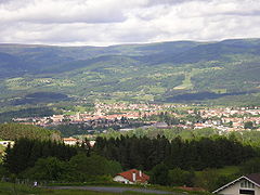 Ambert.
 -
 Saint Jean church.
 -
 Train station of Ambert.
 -
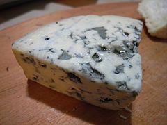 Fourme d'Ambert blue cheese.


Related pages[change | change source]
References[change | change source]
- ↑ "Les élus – Les permanences" (in French). Ville d'Ambert. Retrieved 24 October 2017.
- ↑ "List of Mayors of Puy-de-Dôme" (PDF). Prefecture of Puy-de-Dôme. 9 April 2014. Archived from the original (PDF) on 6 October 2014. Retrieved 1 May 2015.
- ↑ "Commune d'Ambert (63003)". Comparateur de territoire (in French). Institut national de la statistique et des études économiques - INSEE. Retrieved 24 October 2017.
- ↑ "City of Ambert". Map-France.com. Retrieved 24 October 2017.
- ↑ "Puy-de-Dôme" (in French). habitants.fr. Retrieved 24 October 2017.
- ↑ "Régions, départements, arrondissements, cantons et communes" (PDF). Populations légales 2014 (in French). Institut national de la statistique et des études économiques - INSEE. Retrieved 24 October 2017.
Other websites[change | change source]
- City council website (in French)
- Office of tourism website Archived 2008-12-29 at the Wayback Machine (in French)