
Anthonyville, Arkansas
Anthonyville, Arkansas | |
|---|---|
 Community building and fire station | |
 Location of Anthonyville in Crittenden County, Arkansas. | |
| Coordinates: 35°2′22″N 90°20′27″W / 35.03944°N 90.34083°W | |
| Country | United States |
| State | Arkansas |
| County | Crittenden |
| Area | |
| • Total | 0.08 sq mi (0.20 km2) |
| • Land | 0.08 sq mi (0.20 km2) |
| • Water | 0.00 sq mi (0.00 km2) |
| Elevation | 203 ft (62 m) |
| Population (2020) | |
| • Total | 135 |
| • Density | 1,753.25/sq mi (679.95/km2) |
| Time zone | UTC-6 (Central (CST)) |
| • Summer (DST) | UTC-5 (CDT) |
| FIPS code | 05-01457 |
| GNIS feature ID | 1852795[2] |
Anthonyville is a town in the US state of Arkansas.
References[change | change source]
- ↑ "2020 U.S. Gazetteer Files". United States Census Bureau. Retrieved October 29, 2021.
- ↑ 2.0 2.1 U.S. Geological Survey Geographic Names Information System: Anthonyville, Arkansas
Municipalities and communities of Crittenden County, Arkansas, United States | ||
|---|---|---|
| Cities | 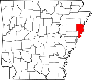 | |
| Towns | ||
| Unincorporated communities | ||