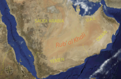
Arabian Peninsula

The Arabian Peninsula is a peninsula in Southwest Asia at the junction of Africa and Asia. It lies east of Ethiopia and northern Somalia; south of Iraq and Jordan; and southwest of Iran. The waters around it are: on the southwest the Red Sea and Gulf of Aqaba; on the southeast the Arabian Sea; and on the northeast the Gulf of Oman and the Persian Gulf. The Arabian Peninsula is usually cited as the largest peninsula in the world with an area of 3,237,500 square kilometers.

It includes the countries of:
- Kuwait
- Oman
- Qatar
- Saudi Arabia which covers most of the peninsula
- United Arab Emirates
- Yemen
The majority of the population of the peninsula live in Saudi Arabia and Yemen. Northern Arabia has oil wells. Climate change and the scarcity of water is said to have affected this area.[1]
A prominent feature of the peninsula is desert. In Hejaz and the southwest there are mountain ranges which may get more rain than the rest of the peninsula.
Related pages[change | change source]
References[change | change source]
Other websites[change | change source]
- Arabia British Foreign Office, 1920
