
Ariège (department)
Ariège | |
|---|---|
 The castle of Foix, Ariège. | |
 Flag  Coat of arms | |
 Location of Ariège in France | |
| Coordinates: 43°00′N 1°30′E / 43.000°N 1.500°E | |
| Country | France |
| Region | Occitanie |
| Prefecture | Foix |
| Subprefectures | Pamiers, Saint-Girons |
| Government | |
| • President | Henri Nayrou |
| Area | |
| • Total | 4,889.9 km2 (1,888.0 sq mi) |
| Population (2014)[3] | |
| • Total | 152,574 |
| • Rank | 95th |
| • Density | 31/km2 (81/sq mi) |
| Demonym(s) | Ariègeois, Ariègeoise |
| Time zone | UTC+1 (CET) |
| • Summer (DST) | UTC+2 (CEST) |
| ISO 3166 code | FR-09 |
| Department number | 09 |
| Arrondissements | 3 |
| Cantons | 13 |
| Communes | 331 |
| Website | www.ariege.fr |
Ariège (Catalan: Arieja; Occitan: Arièja) is a department in the region of Occitanie in southern France; it is named after the Ariège river that flows through the department.
Its capital is the city of Foix but the city with the largest population is Pamiers.
History[change | change source]
The department was inhabited in prehistoric times, as evidenced by the presence of caves with cave paintings and dolmens. In historical times it was inhabited by Basque people; they settled on the northern side of the Pyrenees and in the valleys below. In 415 it became part of the kingdom of the Visigoths, until their defeat at the hands of the king of the Franks in 507.
Ariège was created in 1790 during the French Revolution, when the whole of France was divided into departments, replacing the old provinces. Ariège was created combining the counties[N 1] of Foix (Languedoc) and Couserans (Gascogne).[4]
Geography[change | change source]
Ariège is part of the Occitanie region and has an area of 4,889.9 km2 (1,888 sq mi).[2]
The department is surrounded by the French departments of Haute-Garonne to the west and north, Aude to the east, and Pyrénées-Orientales in the southeast, as well as Spain (Lleida) and Andorra in the south.
Places next to Ariège (department) | |
|---|---|
Natural regions[change | change source]
There are three main natural regions in the department:
- The Ariège plain. The north of the department consists of plains, small hills and low valleys where agriculture is an important activity. Two major rivers, the Ariège and the Lèze, flow through the plain from south to north.
- The Pyrenean foothills. This area includes the small mountains and hills below 1,000 m (3,281 ft).
- The Ariége high country. The geography is dominated by the Pyrenees mountains exceeding 1,000 m (3,281 ft) above sea level which form the border between France and Spain.
The highest mountain in the department is the Pica d'Estats (42°40′1″N 01°23′52″E / 42.66694°N 1.39778°E) that is 3,143 m (10,312 ft) high and is on the Spain-France border.[5] Other high mountains are the peak of Montcalm (3,077 m) and the Pic de Sotllo (3,072 m).
The main river is the Ariège river, a tributary of the Garonne river. Another important river is the Lèze, a tributary of the Ariège.
Climate[change | change source]
Two main types of climate are found in Ariège:
- Mediterranean – particularly visible in the vegetation of the foothills and of the valley of the Ariège river towards Tarascon, and in the Sault country
- Continental – in the Pyrenean valleys, with many storms and big differences of temperature between day and night
Temperatures are mild in the foothills, e.g. at the city of Foix (400 metres) the average is 5 °C in January and 19 °C in July. However, they decline rapidly with elevation, e.g. at l'Hospitalet-près-l'Andorre (1,430 m) it is 0 °C in January and 14 °C in July.
| Climate data for Saint-Girons | |||||||||||||
|---|---|---|---|---|---|---|---|---|---|---|---|---|---|
| Month | Jan | Feb | Mar | Apr | May | Jun | Jul | Aug | Sep | Oct | Nov | Dec | Year |
| Average high °C (°F) | 9.9 (49.8) |
11.1 (52.0) |
12.9 (55.2) |
15.0 (59.0) |
18.5 (65.3) |
22.0 (71.6) |
25.0 (77.0) |
24.5 (76.1) |
22.9 (73.2) |
18.8 (65.8) |
13.5 (56.3) |
10.4 (50.7) |
17 (63) |
| Daily mean °C (°F) | 5.1 (41.2) |
6.1 (43.0) |
7.7 (45.9) |
10.1 (50.2) |
13.3 (55.9) |
16.7 (62.1) |
19.4 (66.9) |
19.0 (66.2) |
17.0 (62.6) |
13.1 (55.6) |
8.3 (46.9) |
5.5 (41.9) |
11.8 (53.2) |
| Average low °C (°F) | 0.3 (32.5) |
1.1 (34.0) |
2.6 (36.7) |
5.1 (41.2) |
8.1 (46.6) |
11.5 (52.7) |
13.7 (56.7) |
13.6 (56.5) |
11.1 (52.0) |
7.5 (45.5) |
3.1 (37.6) |
0.7 (33.3) |
6.5 (43.7) |
| Average precipitation mm (inches) | 92.5 (3.64) |
78.3 (3.08) |
92.9 (3.66) |
98.3 (3.87) |
108.8 (4.28) |
90.0 (3.54) |
62.4 (2.46) |
74.0 (2.91) |
73.2 (2.88) |
77.5 (3.05) |
77.2 (3.04) |
88.3 (3.48) |
1,013.4 (39.90) |
| Average precipitation days (≥ 1 mm) | 11.4 | 10.6 | 12.2 | 13.0 | 13.2 | 9.5 | 7.6 | 9.1 | 8.4 | 8.9 | 9.8 | 11.0 | 124.7 |
| Mean monthly sunshine hours | 113.6 | 123.7 | 160.8 | 157 | 180.3 | 195.2 | 227.8 | 205.4 | 199.9 | 173.6 | 127.4 | 107.4 | 1,972 |
| Source: Metereological data for Saint-Girons - Antichan from 1961 to 1990 July 2013 | |||||||||||||
Administration[change | change source]
The department is managed by the Departamental Council of the Ariège in Foix. Ariège is part of the region of Occitanie.
Administrative divisions[change | change source]
There are 3 arrondissements (districts), 13 cantons and 332 communes (municipalities) in Ariège.[6]
| INSEE code |
Arrondissement | Capital | Population[7] (2014) |
Area[8] (km²) |
Density (Inh./km²) |
Communes |
|---|---|---|---|---|---|---|
| 091 | Foix | Foix | 51,473 | 2,077.8 | 24.8 | 135 |
| 092 | Pamiers | Pamiers | 73,702 | 1,315.0 | 56.0 | 115 |
| 093 | Saint-Girons | Saint-Girons | 27,399 | 1,497.2 | 18.3 | 82 |
-
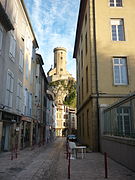 The "old city", Foix
 -
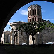
 Cathedral of Saint-Antonin at Pamiers
 -
 St Girons' Church by the Salat river

.JPG)
_-_%C3%89glise_Saint-Girons_-_20070625.jpg)
The following is a list of the 13 cantons of the Ariège department (with their INSEE codes), following the French canton reorganisation which came into effect in March 2015:[9]
- Haute-Ariège (0901)
- Arize-Lèze (0902)
- Couserans Est (0903)
- Couserans Ouest (0904)
- Foix (0905)
- Mirepoix (0906)
- Pamiers-1 (0907)
- Pamiers-2 (0908)
- Pays d'Olmes (0909)
- Portes d'Ariège (0910)
- Portes du Couserans (0911)
- Sabarthès (0912)
- Val d'Ariège (0913)
Demographics[change | change source]
The inhabitants of Ariège are known, in French, as ariègeois (women: ariègeoises).[10]
Ariège has a population, in 2014, of 152,574,[3] for a population density of 31.2 inhabitants/km2. The arrondissement of Pamiers, with 73,702 inhabitants, is by far the one with more inhabitants. The other two, Foix and Saint-Girons, have respectively 51,473 and 27,399 inhabitants.[7]
Evolution of the population in Ariège

About 25% of the population lives in the four communes with 6,000 or more inhabitants.[11]
The 10 most important cities in the department are:
| City | Population[7] (2014) |
Arrondissement |
|---|---|---|
| Pamiers | 15,518 | Pamiers |
| Foix | 9,721 | Foix |
| Saint-Girons | 6,284 | Saint-Girons |
| Lavelanet | 6,245 | Foix |
| Saverdun | 4,658 | Pamiers |
| Mazères | 3,810 | Pamiers |
| Varilhes | 3,328 | Pamiers |
| Tarascon-sur-Ariège | 3,322 | Foix |
| Mirepoix | 3,148 | Pamiers |
| La Tour-du-Crieu | 3,071 | Pamiers |
Economy[change | change source]
Agriculture is an important activity in Ariege. Only a small part of its territory is used by farmers; only 132,110 hectares (326,451 acres), 27% of its total area, are used for agriculture in the Ariege.[12]
The Ariège plain is the most fertile area of the department; here farmers grow maize, wheat, sunflower and other crops. The other natural regions are not good for agriculture and are covered with forests or are used for pastures for sheep, cattle and horses.[12]
In the Ax valleys, the mining of talc is the most typical activity. This industry is supplemented by tourism for winter sports.
Hydroelectric production is about one-fifth of the production in the Pyrenees. The hydroelectric plant at Aston has the largest annual production capacity in the Pyrenees.
Gallery[change | change source]
-
-
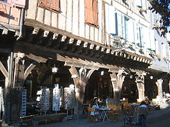 Covered shopfronts at Mirepoix.
 -
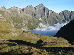 Mont Valier seen from the road to Port d'Aula in the Haut Couserans.
 -

-
 The Château de Lagarde.
 -
 The cloister in the Saint-Lizier Cathedral.
 -
 The Massif of Tabe.


.jpg)

Related pages[change | change source]
Notes[change | change source]
References[change | change source]
- ↑ "Le Président du Conseil Départemental" (in French). Conseil Départemental de l'Ariège. Archived from the original on 26 March 2017. Retrieved 23 March 2017.
- ↑ 2.0 2.1 "Département de l'Ariège (09) - Résumé statistique". Publications et statistiques pour la France ou les régions (in French). Institut national de la statistique et des études économiques - INSEE. Retrieved 10 February 2015.
- ↑ 3.0 3.1 "Populations légales 2014 des départements et des collectivités d'outre-mer" (in French). Institut national de la statistique et des études économiques - INSEE. Retrieved 6 January 2017.
- ↑ "Description de l'Ariège". Le SPLAF (in French). Retrieved 31 July 2013.
- ↑ "Pica d'Estats". To Know Catalonia. explora.cat. Retrieved 31 July 2013.
- ↑ "Département de l'Ariège (09)" (in French). Institut national de la statistique et des études économiques - INSEE. Retrieved 23 March 2017.
- ↑ 7.0 7.1 7.2 "Régions, départements, arrondissements, cantons et communes" (PDF). Populations légales 2014 (in French). Institut national de la statistique et des études économiques - INSEE. Retrieved 7 January 2017.
- ↑ "Département de l'Ariège (09) et Arrondissements". Comparateur de territoire (in French). Institut national de la statistique et des études économiques - INSEE. Retrieved 6 January 2017.
- ↑ "Décret n° 2014-174 du 18 février 2014 portant délimitation des cantons dans le département de l'Ariège" (in French). Légifrance.gouv.fr. Retrieved 21 July 2015.
- ↑ "Habitants du départment: Ariège" (in French). habitants.fr. Retrieved 31 July 2013.
- ↑ "Le département de l'Ariège : population, emploi et surfaces". Terres d'Ariège (in French). Archived from the original on 20 July 2014. Retrieved 31 July 2013.
- ↑ 12.0 12.1 "L'Agriculture ariégeose". Terres d'Ariège (in French). Archived from the original on 20 July 2014. Retrieved 31 July 2013.
Other websites[change | change source]
- Departamental Council of the Ariège Archived 2015-03-18 at the Wayback Machine (in French)
- Ariège 2020 - agenda 21 Archived 2013-05-18 at the Wayback Machine (in French)
- Prefecture website[permanent dead link] (in French)
- The Ariège Pyrenees Archived 2013-08-01 at the Wayback Machine
- Ariege Pyrenees Tourism Archived 2013-07-24 at the Wayback Machine
- Pays des Portes d'Ariège-Pyrénées (in French)
- Histariège - Histoire et Patrimoine de l'Ariège Archived 2019-01-02 at the Wayback Machine (in French)
| International | |
|---|---|
| National | |
| Geographic | |