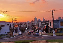
Assis
The Municipality of
Assis Assisense Assis, São Paulo, Brasil | |
|---|---|
Municipality | |
 Rui Barbosa Avenue | |
| Nickname(s): Capital do Paranapanema Paranapanema's Capital Cidade Fraternal Fraternal City | |
| Motto(s): Deo et terræ matri God and land mother | |
 | |
| Coordinates: 22°39′43″S 50°24′43″W / 22.66194°S 50.41194°W | |
| Country | Brazil |
| State | São Paulo |
| Foundation | July 5, 1905 |
| Municipality | December 20, 1917 [1] |
| Creation of city of Tarumã | January 9, 1990 [2] |
| Government | |
| • Mayor | José Aparecido Fernandes (2016-2020) |
| Area | |
| • Total | 462,705 km2 (178,651 sq mi) |
| Elevation | 543 m (1,781 ft) |
| Population (2020) | |
| • Total | 105,087 |
| • Density | 207/km2 (540/sq mi) |
| Estimative | |
| Demonym | Assisense |
| Time zone | UTC−3 (BRT) |
| • Summer (DST) | UTC−2 (BRST) |
| Postal Code (CEP) | 19800-000 |
| Area code | 18 |
| maxtemp | 31 |
| mintemp | 11 |
| rainfall | 1441 |
| Website | http://www.assis.sp.gov.br/ |
Assis is a Brazilian city in the southwestern part of the state of São Paulo. Its population, in 2013, was 100,911 inhabitants. It has an area of 462 km². It was named for the city's founder Captain Francisco Nogueira Acis. [4] The spelling was later changed to add another 's'.[4]
References[change | change source]
- ↑ "Cria o municipio de Assis, na comarca de Campos Novos do Paranapanema" (in Portuguese).
- ↑ "Dispõe sobre alterações no Quadro Territorial-Administrativo do Estado" (in Portuguese).
- ↑ IBGE (10 October 2002). "Área territorial oficial" (in Portuguese). Resolução da Presidência do IBGE de n° 5 (R.PR-5/02).
- ↑ 4.0 4.1 "História da Cidade". Câmara Municipal de Assis. Archived from the original on 4 January 2014. Retrieved 12 February 2015.
Other websites[change | change source]


