Bensalem Township, Pennsylvania
Bensalem Township, Pennsylvania | |
|---|---|
 Andalusia, a NRHP site in Bensalem | |
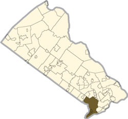
 Location of Bensalem Township in Bucks County, Pennsylvania | |
Location of Bensalem in Pennsylvania | |
| Coordinates: 40°06′46″N 74°56′36″W / 40.11278°N 74.94333°W | |
| Country | United States |
| State | Pennsylvania |
| County | Bucks |
| Government | |
| • Type | Mayor-council |
| Area | |
| • Total | 21.0 sq mi (54 km2) |
| • Land | 20.0 sq mi (52 km2) |
| • Water | 1.0 sq mi (3 km2) |
| Elevation | 102 ft (31 m) |
| Population | |
| • Total | 62,707 |
| • Density | 3,000/sq mi (1,200/km2) |
| Time zone | UTC-5 (EST) |
| • Summer (DST) | UTC-4 (EDT) |
| ZIP Codes | 19020, 19053 |
| Area codes | 215, 267, and 445 |
| FIPS code | 42-017-05616 |
| Website | https://www.bensalempa.gov/ |
Bensalem Township is a township in Bucks County, Pennsylvania, United States and borders the northeast section of Philadelphia.
References[change | change source]
- ↑ "2016 U.S. Gazetteer Files". United States Census Bureau. Retrieved Aug 13, 2017.
- ↑ "QuickFacts: Bensalem township, Bucks County, Pennsylvania". U.S. Census Bureau. Retrieved March 12, 2024.


