
Bergerac
Bergerac | |
|---|---|
Subprefecture and commune | |
 Bergerac overlooking the Dordogne river | |
.svg) Coat of arms | |
Location of Bergerac  | |
 Bergerac  Bergerac | |
| Coordinates: 44°51′N 0°29′E / 44.85°N 0.48°E | |
| Country | France |
| Region | Nouvelle-Aquitaine |
| Department | Dordogne |
| Arrondissement | Bergerac |
| Canton | Bergerac-1 and 2 |
| Intercommunality | Bergerac Pourpre |
| Government | |
| • Mayor (2014–2020) | Daniel Garrigue |
| Area 1 | 56.10 km2 (21.66 sq mi) |
| Population (2014) | 27,764 |
| • Density | 490/km2 (1,300/sq mi) |
| Demonym | Bergeracois |
| Time zone | UTC+01:00 (CET) |
| • Summer (DST) | UTC+02:00 (CEST) |
| INSEE/Postal code | 24037 /24100 |
| Elevation | 12–146 m (39–479 ft) (avg. 79 m or 259 ft) |
| Website | www.ville-bergerac.fr |
| 1 French Land Register data, which excludes lakes, ponds, glaciers > 1 km2 (0.386 sq mi or 247 acres) and river estuaries. | |
Bergerac (Occitan: Brageirac)[1] is a commune and a subprefecture of the Dordogne department in the Nouvelle-Aquitaine region, southwestern France.
It is the second biggest city of the department, after Périgueux.
Despite the similarities in their names, there is no connection to Cyrano de Bergerac, a French writer from Paris.
Geography[change | change source]
Bergerac is in the south of the Dordogne department, in the region named as Périgord Pourpre; the Dordogne river flows through the city.
The city is at about 48 km (30 mi) from Périgueux, 90 km (56 mi) from Agen, 93 km (58 mi) from Bordeaux and 110 km (68 mi) from Cahors.
It has an area of 56.10 km2 (21.66 sq mi) and its average altitude is 79 m (259 ft); at the city hall, the altitude is 39 m (128 ft).[2]

|
Bergerac is surrounded by the communes Ginestet, Maurens, Lembras, Creysse, Cours-de-Pile, Saint-Nexans, Colombier, Monbazillac, Saint-Laurent-des-Vignes and Prigonrieux.
Places next to Bergerac | |
|---|---|
Climate[change | change source]
The climate of Bergerac is a Mediterranean climate (Marine West Coast Climate), Cfb in the Köppen climate classification, with mild winters and warm summers.
Population[change | change source]
The inhabitants of Bergerac are known, in French, as Bergeracois (women: Bergeracoises).[3]
With a population of 27,764 (2014),[4] Bergerac has a population density of 495 inhabitants/km2.
Evolution of the population in Bergerac

Bergerac forms with 22 other communes, including four communes that are part of the Gironde department,[5] the urban area of Bergerac with a population of 64,968 inhabitants (2013) and an area of 188.4 km2 (72.7 sq mi).[6] This urban area is the centre of the metropolitan area of Bergerac, formed by 67 communes with a population of 81,574 inhabitants and an area of 870 km2 (340 sq mi).[7]
Administration[change | change source]
Bergerac is a subprefecture of the Dordogne department since 1790, and the capital of the arrondissement of Bergerac.
The commune is the administrative centre (French: chef-lieu) of two cantons:
- Bergerac-1, formed with a part of Bergerac;[8] and
- Bergerac-2, formed with the remaining part of Bergerac and 9 other communes.[9]
It is part of the intercommunality Bergeracoise (French: Communauté d'agglomération bergeracoise).
Twin towns[change | change source]
Economy[change | change source]
Bergerac is known for its wines and its tobacco. It has 12 recognized wine kinds that are Appellation d'origine contrôlée (AOC).
Gallery[change | change source]
-
 Bergerac town hall.
 -
 Houses in the Old Bergerac.
 -
 Bergerac and the Dordogne river.
 -
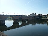 The old bridge of Bergerac.


.JPG)

Related pages[change | change source]
References[change | change source]
- ↑ "Bergerac" (in French). Le nom occitan des communes du Périgord. Archived from the original on 3 March 2016. Retrieved 1 April 2015.
- ↑ "City of Bergerac". Map-France.com. Retrieved 1 April 2015.
- ↑ "Bergerac (24100)" (in French). habitants.fr. Retrieved 1 April 2015.
- ↑ "Régions, départements, arrondissements, cantons et communes" (PDF). Populations légales 2014 (in French). Institut national de la statistique et des études économiques - INSEE. Retrieved 11 March 2017.
- ↑ "Unité urbaine de Bergerac (00553)". Géographie administrative et d’étude (in French). Institut national de la statistique et des études économiques - INSEE. Retrieved 11 March 2017.
- ↑ "Unité urbaine de Bergerac (00553)". Comparateur de territoire (in French). Institut national de la statistique et des études économiques - INSEE. Retrieved 11 March 2017.
- ↑ "Aire urbaine de Bergerac (109)". Comparateur de territoire (in French). Institut national de la statistique et des études économiques - INSEE. Retrieved 11 March 2017.
- ↑ "Canton de Bergerac-1 (2401)" (in French). Institut national de la statistique et des études économiques - INSEE. Retrieved 11 March 2017.
- ↑ "Canton de Bergerac-2 (2402)" (in French). Institut national de la statistique et des études économiques - INSEE. Retrieved 11 March 2017.
- ↑ "Jumelages & Relations internationales" (in French). Ville de Bergerac. Archived from the original on 4 April 2015. Retrieved 1 April 2015.
Other websites[change | change source]
- Ville de Bergerac - Official site[permanent dead link] (in French)
- Office de Tourisme Bergerac (in French)
- Departamental Council of Dordogne (in French)
- Prefecture official website (in French)
- Région Nouvelle-Aquitaine (in French)
| International | |
|---|---|
| National | |
| Geographic | |
| Other | |