
Bern
Bern Berne | |
|---|---|
 Aerial view of the Old City | |
 Coat of arms | |
Location of Bern Berne  | |
 Bern Berne  Bern Berne | |
| Coordinates: 46°56′53″N 7°26′51″E / 46.94806°N 7.44750°E | |
| Country | Switzerland |
| Canton | Bern |
| District | Bern-Mittelland administrative district |
| Government | |
| • Executive | Gemeinderat with 5 members |
| • Mayor | Stadtpräsident (list) Alec von Graffenried GFL (as of January 2021) |
| • Parliament | Stadtrat with 80 members |
| Area | |
| • Total | 51.62 km2 (19.93 sq mi) |
| Elevation (Bahnhofplatz) | 540 m (1,770 ft) |
| Highest elevation (Könizberg) | 674 m (2,211 ft) |
| Lowest elevation (Aare near to Eymatt) | 481 m (1,578 ft) |
| Population (31 December 2018)[2] | |
| • Total | 133,883 |
| • Density | 2,600/km2 (6,700/sq mi) |
| Demonym(s) | English: Bernese, German: Berner(in), French: Bernois(e), Italian: Bernese |
| Time zone | UTC+01:00 (Central European Time) |
| • Summer (DST) | UTC+02:00 (Central European Summer Time) |
| Postal code(s) | 3000–3030 |
| SFOS number | 0351 |
| Localities | Altenberg, Aaregg, Bümpliz, Bethlehem, Beundenfeld, Bottigen, Breitenrain, Breitfeld, Brunnadern, Dählhölzli, Engeried, Gäbelbach, Grosser Bremgartenwald, Gryphenhübeli, Felsenau, Holligen, Innere Stadt, Kirchenfeld, Könizbergwald, Länggasse, Lorraine, Muesmatt, Murifeld, Neufeld, Sandrain, Schosshalde, Spitalacker, Stöckacker, Tiefenau, Wankdorf, Weissenbühl, Weissenstein |
| Surrounded by | Bremgarten bei Bern, Frauenkappelen, Ittigen, Kirchlindach, Köniz, Mühleberg, Muri bei Bern, Neuenegg, Ostermundigen, Wohlen bei Bern, Zollikofen |
| Website | www SFSO statistics |
Bern (French: Berne, Italian: Berna, Romansh: Berna, Bernese German: Bärn) is the capital city of Switzerland. It is also the capital of the canton of Bern.
As of early 2006, 127.000 people lived in the city.
History[change | change source]
Bern was started in 1191 by Berchthold V. von Zähringen. A legend says that he said he would name the city after the next animal he caught. So when he caught a bear (German: "Bär") the city was named Bern. Zähringen built the city in the half-circle the river Aare makes.
Traffic[change | change source]
Public streetcars and buses are run by an organization called BernMobil. There are 3 streetcar lines and about 15 bus lines. Most of the lines are in the city but some travel away from the city. There is also the Marzilibahn, a funicular (inclined- or cliff-railway) which goes from the banks of the Aare up to the Federal Building (German: "Bundeshaus"). The Marzilibahn is 105 meters long. It is the shortest funicular in Europe. Another funicular, called the Gurtenbahn, goes from the section of Bern called Wabern, which is on the river Aare, up to the top of Gurten, a large hill 585 meters high that is just south of Bern. A small airport, Belpmoos, is located a short distance south of Bern in Belp.
Folk Festivals[change | change source]
Zibelemärit (onion market)[change | change source]
Each year, on the 4th Monday in November, there is the Onion Market in Bern, where onions are sold. Many people visit the market in the early morning and throw confetti. They also hit other people with hammers made out of plastic
Aareleuchten (glowing Aare)[change | change source]
Since 1996, every August 1 (a national holiday in Switzerland) they hold the Aareleuchten. The Aareleuchten is paid for by SwissAid. During the festival, people put small ships with a light in them into the river Aare. All of these small lights make the Aare "glow."
Gallery[change | change source]
-
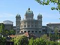 The Swiss parliament building in Bern
 -
 View towards the cathedral called "Münster"
 -
 One of the many fountains in the old part of the city
 -
 View over the river Aare towards the modern part of the city.
 -
 Another picture of the Aare in Bern


References[change | change source]
- ↑ 1.0 1.1 "Arealstatistik Standard - Gemeinden nach 4 Hauptbereichen". Federal Statistical Office. Retrieved 13 January 2019.
- ↑ Error: Unable to display the reference properly. See the documentation for details.
Other websites[change | change source]
- Official website
- Bern Public Transportation Website (BernMobil)
- Bern (Gemeinde) in German, French and Italian in the online Historical Dictionary of Switzerland, 10 November 2016.
- "GIS City of Bern". Archived from the original on 28 September 2007. Retrieved 23 April 2006.
{{cite web}}: CS1 maint: bot: original URL status unknown (link) - Gurtenfestival
- Buskers Bern
Capitals of Swiss cantons | |||
|---|---|---|---|
 | Aarau (Aargau) - Altdorf (Uri) - Appenzell (Appenzell Innerrhoden) - Basel (Basel-City) - Bellinzona (Ticino) - Bern (Bern) - Chur (Graubünden) - Delémont (Jura) - Frauenfeld (Thurgau) - Fribourg (Fribourg) - Geneva (Geneva) - Glarus (Glarus) - Herisau/Trogen (Appenzell Ausserrhoden) - Lausanne (Vaud) - Liestal (Basel-Land) - Lucerne (Lucerne) - Neuchâtel (Neuchâtel) - St. Gallen (St. Gallen) - Sarnen (Obwalden) - Schaffhausen (Schaffhausen) - Schwyz (Schwyz) - Sion (Valais) - Solothurn (Solothurn) - Stans (Nidwalden) - Zug (Zug) - Zürich (Zürich) | | |
| International | |
|---|---|
| National | |
| Geographic | |
| Other | |