
Bradley County, Arkansas
Bradley County | |
|---|---|
 Bradley County Courthouse | |
 Location within the U.S. state of Arkansas | |
 Arkansas's location within the U.S. | |
| Coordinates: 33°29′39″N 92°08′42″W / 33.494166666667°N 92.145°W | |
| Country | |
| State | |
| Founded | December 18, 1840 |
| Named for | Hugh Bradley |
| Seat | Warren |
| Largest city | Warren |
| Area | |
| • Total | 653 sq mi (1,690 km2) |
| • Land | 649 sq mi (1,680 km2) |
| • Water | 3.7 sq mi (10 km2) 0.6% |
| Population | |
| • Total | 10,545 |
| • Density | 16/sq mi (6.2/km2) |
| Time zone | UTC−6 (Central) |
| • Summer (DST) | UTC−5 (CDT) |
| Website | www |
Bradley County is a county of the U.S. state of Arkansas. As of the 2020 census, the population was 10,545.[1] The county seat is Warren.[2] It was founded on December 18, 1840.
References[change | change source]
- ↑ 1.0 1.1 "QuickFacts: Bradley County, Arkansas". United States Census Bureau. Retrieved August 8, 2023.
- ↑ "Find a County". National Association of Counties. Archived from the original on 2011-05-31. Retrieved 2011-06-07.
Municipalities and communities of Bradley County, Arkansas, United States | ||
|---|---|---|
| Cities | 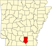 | |
| Town | ||
| Unincorporated communities | ||
