Cachoeiro de Itapemirim
Cachoeiro de Itapemirim | |
|---|---|
| Município de Cachoeiro de Itapemirim Municipality of Cachoeiro de Itapemirim | |
 Montages of the city Cachoeiro de Itapemirim. Top left: Sunset in River Itapemirim, Top right: View of Center of Cachoeiro de Itapemirim, Middle left: St. Peter's Cathedral, Middle right: River Itapemirim, Bottom left: Night view of Iron Bridge Demisthóclides Baptista, Bottom right: Fátima Square. | |
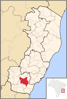
 Localization in Espírito Santo | |
| Coordinates: 20°50′56″S 41°06′46″W / 20.84889°S 41.11278°W | |
| Country | |
| Region | Southeast |
| State | |
| Founded | November 11, 1890 |
| Government | |
| • Type | Mayor-council |
| • Body | Prefeitura da Cidade de Cachoeiro de Itapemirim |
| • Mayor | Victor Coelho (PSB (2017–2020)) |
| Area | |
| • Total | 864.583 km2 (333.817 sq mi) |
| Elevation | 22 m (72 ft) |
| Population (2020 est.[2]) | |
| • Total | 210,589 |
| • Rank | 2nd |
| • Density | 240/km2 (630/sq mi) |
| Demonym | Cachoeirense |
| Time zone | UTC−3 (BRT) |
| Area code | +55 28 |
Cachoeiro de Itapemirim (local Portuguese pronunciation: [kaʃuˈe(j)ɽu ˌdʒiːtapemiˈɾĩj]) is a city in the south of Espírito Santo, Brazil. The population is about 210,000.
References[change | change source]
- ↑ "Brazilian Institute of Geography and Statistics" (in Portuguese). 2017. Retrieved 27 March 2019.
2018 Area Total
- ↑ IBGE 2020


