
Carmarthen
Carmarthen
| |
|---|---|
 Carmarthen town centre | |
 Carmarthen | |
| Location within Carmarthenshire | |
| Population | 16,285 (2019) |
| OS grid reference | SN415205 |
| Principal area | |
| Ceremonial county | |
| Country | Wales |
| Sovereign state | United Kingdom |
| Post town | CARMARTHEN |
| Postcode district | SA31, SA32, SA33 |
| Dialling code | 01267 |
| Police | Dyfed-Powys |
| Fire | Mid and West Wales |
| Ambulance | Welsh |
| UK Parliament | |
Carmarthen (Welsh: Caerfyrddin) is a community and town in Carmarthenshire in South West Wales. In 2019, it was found that 16,285 people live there.
It is Carmarthenshire's county town, but the largest town in Llanelli.
The town's name in Welsh means Merlin's fort or Sea-town fort.
It is said to be Wales' oldest town after Old Carmarthen and New Carmarthen became one borough in 1546.
It has a castle, Carmarthen Castle.
Transport[change | change source]
Carmarthen railway station is an important junction train station on the West Wales line.
Twinning[change | change source]
Carmarthen is twinned with:
 Lesneven, France
 Santa Marinella, Italy
 As Pontes de García Rodríguez, Spain
Gallery[change | change source]
-
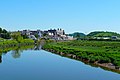 Carmarthen viewed from Lesneven Bridge
 -

-


| International | |
|---|---|
| National | |
| Geographic | |