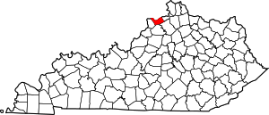
Carroll County, Kentucky
Carroll County | |
|---|---|
 Carroll County Courthouse in Carrollton | |
 Location within the U.S. state of Kentucky | |
 Kentucky's location within the U.S. | |
| Coordinates: 38°40′N 85°08′W / 38.67°N 85.13°W | |
| Country | |
| State | |
| Founded | 1838 |
| Named for | Charles Carroll of Carrollton |
| Seat | Carrollton |
| Largest city | Carrollton |
| Area | |
| • Total | 137 sq mi (350 km2) |
| • Land | 129 sq mi (330 km2) |
| • Water | 8.7 sq mi (23 km2) 6.4% |
| Population (2020) | |
| • Total | 10,810 |
| • Density | 79/sq mi (30/km2) |
| Time zone | UTC−5 (Eastern) |
| • Summer (DST) | UTC−4 (EDT) |
| Congressional district | 4th |
| Website | www |
Carroll County is a county in Kentucky. Its county seat is Carrollton.
