Clarkstown, New York
Clarkstown, New York | |
|---|---|
 Hook Mountain in Autumn | |
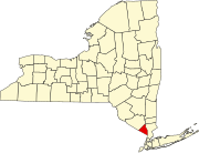
 Location in Rockland County and the state of New York. | |
| Coordinates: 41°7′34″N 73°58′49″W / 41.12611°N 73.98028°W | |
| Country | United States |
| State | New York |
| County | Rockland |
| Established | March 18, 1791 |
| Area | |
| • Total | 47.06 sq mi (121.90 km2) |
| • Land | 38.46 sq mi (99.62 km2) |
| • Water | 8.60 sq mi (22.28 km2) |
| Elevation | 105 ft (32 m) |
| Population | |
| • Total | 86,855 |
| • Density | 2,258.1/sq mi (871.9/km2) |
| Time zone | UTC-5 (Eastern (EST)) |
| • Summer (DST) | UTC-4 (EDT) |
| ZIP code | 10956 (New City), 10920 (Congers), 10954 (Nanuet), 10960 (Nyack), 10989 (Valley Cottage), 10994 (West Nyack) |
| Area code | 845 |
| FIPS code | 36-15968 |
| GNIS feature ID | 0978832 |
| Website | www |
Clarkstown is a town in Rockland County, New York, United States. As of the 2020 census, the town had a total population of 86,855.[2]
References[change | change source]
- ↑ "2020 U.S. Gazetteer Files". United States Census Bureau. Retrieved March 7, 2024.
- ↑ 2.0 2.1 "Profile of General Population and Housing Characteristics: 2020 Demographic Profile Data (DP-1): Clarkstown town, Rockland County, New York". United States Census Bureau. Retrieved March 7, 2024.


