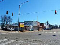
Columbia, Alabama
Columbia, Alabama | |
|---|---|
 Columbia, Alabama in 2012 | |
 Location of Columbia in Houston County, Alabama. | |
| Coordinates: 31°17′32″N 85°6′43″W / 31.29222°N 85.11194°W | |
| Country | United States |
| State | Alabama |
| County | Houston |
| Area | |
| • Total | 4.00 sq mi (10.35 km2) |
| • Land | 3.93 sq mi (10.18 km2) |
| • Water | 0.07 sq mi (0.17 km2) |
| Elevation | 223 ft (68 m) |
| Population | |
| • Total | 690 |
| • Density | 175.53/sq mi (67.77/km2) |
| Time zone | UTC-6 (Central (CST)) |
| • Summer (DST) | UTC-5 (CDT) |
| ZIP code | 36319 |
| Area code | 334 |
| FIPS code | 01-16744 |
| GNIS feature ID | 0116457 |
Columbia is a town in Houston County, Alabama, United States. At the 2020 census the population was 690, down from 740 in 2010.[2] It is part of the Dothan Metropolitan Statistical Area.
References[change | change source]
- ↑ "2020 U.S. Gazetteer Files". United States Census Bureau. Retrieved October 29, 2021.
- ↑ 2.0 2.1 "Columbia town, Alabama". United States Census Bureau. Retrieved September 1, 2023.

