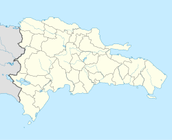
Comendador, Dominican Republic
Comendador | |
|---|---|
Municipality | |
 A street in Comendador | |
| Coordinates: 18°52′38″N 71°42′11″W / 18.87722°N 71.70306°W | |
| Country | |
| Province | Elías Piña |
| Founded | 1868 |
| Municipality since | 1908 |
| Municipal Districts | Sabana Larga, Guayabo |
| Area | |
| • Total | 126.9 km2 (49.0 sq mi) |
| • Urban | 2.90 km2 (1.12 sq mi) |
| Elevation | 395 m (1,296 ft) |
| Population (2010)[1] | |
| • Total | 19,344 |
| • Density | 150/km2 (390/sq mi) |
| Time zone | UTC-4 (AST) |
| • Summer (DST) | UTC-4 (AST) |
| Distance: | 55 km (34 mi) to San Juan 255 km (158 mi) to Santo Domingo |
The Dominican city of Comendador is the head municipality of the Elías Piña province, on the border with Haiti.
Population[change | change source]
The municipality had, in 2010, a total population of 19,344: 9,675 men and 9,669 women. The urban population was 64.1% of the total population.[1]
History[change | change source]
The city was founded in 1868,[4] and named after Nicolás de Ovando, the "Comendador of Lares" (Comendador was the chief of a military or religious order). It was founded where there was a military post close to the border with Haiti. The Taíno name of the region was Duan.[4]
There was several fights between Haitian and Dominican soldiers during the Dominican-Haitian War after 1844. The most important fight was the La Estrelleta Battle in a savanna near Comendador.
The old military post was made a Cantón (now called Municipal District) of the Azua province in 1907. The next year, in 1908, it was elevated to the category of municipality of the same province.
Its name was changed to Villa Elías Piña on 29 November 1930. In 1972, its name was changed back to Comendador..
Geography[change | change source]
Comendador is at 255 km (158 mi) to the west of Santo Domingo and 55 km (34 mi) of San Juan de la Maguana. The limits of the municipality are the municipality of Bánica to the north, the San Juan province to the east, the municipality of El Llano to the south and Haiti to the west.
The average daily temperature in the city is 26.7 °C (80.1 °F) and the average rainfall for the year is 1,828 mm (72.0 in).[3]
Administrative division[change | change source]
The municipality of Comendador has two municipal districts;[1] these are:
| Code | Municipal district | Population (2010) |
Area (km2) |
Density |
|---|---|---|---|---|
| 070102 | Sabana Larga | 2,056 | 101.1 | 20.3 |
| 070103 | Guayabo | 4,524 | 28.1 | 161.0 |
Economy[change | change source]
The main economic activity of the municipality is agriculture. Commerce with Haiti is also an important economic activity in the city.
References[change | change source]
- ↑ 1.0 1.1 1.2 1.3 "IX Censo Nacional de Población y Vivienda. Informe Básico" (PDF) (in Spanish). Oficina Nacional de Estadística. June 2012. Retrieved 9 December 2016.
- ↑ "Expansión Urbana de las ciudades capitales de R.D. 1988-2010. Informe Básico" (PDF) (in Spanish). Oficina Nacional de Estadística. April 2015. p. 36. Retrieved 9 December 2016.[permanent dead link]
- ↑ 3.0 3.1 De la Fuente, Santiago (1976). Geografía Dominicana (in Spanish). Santo Domingo, Dominican Republic: Editora Colegial Quisqueyana.
- ↑ 4.0 4.1 Caamaño Castillo, Rafael E. (1996). Comendador: Apuntes para su Historia (in Spanish). Santo Domingo, República Dominicana: Editora Corripio.
| Provincial capitals of the Dominican Republic | |
|---|---|
| Azua • Baní • Barahona • Bonao • Comendador • Cotuí • Dajabón • El Seibo • Hato Mayor • Higüey • Jimaní • La Romana • La Vega • Mao • Moca • Monte Cristi • Monte Plata • Nagua • Neiba • Pedernales • Puerto Plata • Sabaneta • Salcedo • Samaná • San Cristóbal • San Francisco de Macorís • San José de Ocoa • San Juan de la Maguana • San Pedro de Macorís • Santiago de los Caballeros • Santo Domingo • Santo Domingo Este | |


