
Condom, Gers
Condom | |
|---|---|
Subprefecture and commune | |
 Condom Cathedral. | |
.svg) Coat of arms | |
Location of Condom  | |
 Condom  Condom | |
| Coordinates: 43°58′N 0°22′E / 43.96°N 0.37°E | |
| Country | France |
| Region | Occitanie |
| Department | Gers |
| Arrondissement | Condom |
| Canton | Baïse-Armagnac |
| Intercommunality | La Ténarèze |
| Government | |
| • Mayor (2014–2020) | Gérard Dubrac |
| Area 1 | 97.37 km2 (37.59 sq mi) |
| Population (2014) | 6,835 |
| • Density | 70/km2 (180/sq mi) |
| Demonym | Condomois |
| Time zone | UTC+01:00 (CET) |
| • Summer (DST) | UTC+02:00 (CEST) |
| INSEE/Postal code | 32107 /32100 |
| Elevation | 62–190 m (203–623 ft) (avg. 82 m or 269 ft) |
| Website | www.condom.org |
| 1 French Land Register data, which excludes lakes, ponds, glaciers > 1 km2 (0.386 sq mi or 247 acres) and river estuaries. | |
Condom (Occitan: Condòm), also called Condom-en-Armagnac or Condom-sur-Baïse, is a commune in southwestern France in the department of Gers, Occitanie region, of which it is a subprefecture.
Name of the city[change | change source]
The name Condom comes from the Gaulish (an ancient Celtic language spoken in parts of Europe) words condate-ó-magos which means "market of the confluence". Condatómagos later became Condatóm and then Conddóm. The spelling Condom first came from Latin in the 10th century as Condomus or Condomium.[1]
The name of the town has nothing to do with the condom, which in French is called préservatif. There used to be a museum of condoms in Condom, but it closed in 2005.[2]
History[change | change source]
After the colonization of the area by the Romans, the Abbey of Saint Pierre was built in 1011. During the Hundred Years' War, the city was taken twice by the English. The Saint Pierre Cathedral was begun in 1507.
Way of St. James[change | change source]
Condom is a town on the Via Podiensis (the Le Puy Route), one of the three major French pilgrimage routes of the Way of St. James. This particular route begins in Le Puy and ends in Santiago de Compostela in northwest Spain. Pilgrims came to Condom from Miradoux and continue on to Larressingle.
Geography[change | change source]
Condom is a commune found along the Baïse river, between Armagnac and Agenais. Condom is the main town of the Condomès or Ténarèze region.
The commune has an area of 97.37 km2 (37.59 sq mi) and its average altitude is 82 m (269 ft); at the city hall, the altitude is 73 m (240 ft).[3]

|
Condom is surrounded by the communes:
- Gers department: Gazaupouy, Castelnau-sur-l'Auvignon, Caussens, Béraut, Maignaut-Tauzia, Cassaigne, Larressingle and Larroque-sur-l'Osse,
- Lot-et-Garonne department: Lannes et Moncrabeau.
Places next to Condom, Gers | |
|---|---|
Climate[change | change source]
The climate of Condom, in the Köppen climate classification, is Cfb - Oceanic climate with template summers.
Population[change | change source]
The inhabitants of Condom are known, in French, as Condomois (women: Condomoises).[4]
With a population of 6,835 (2014),[5] Condom has a population density of 70 inhabitants/km2.
Evolution of the population in Condom

Economy[change | change source]
The commune of Condom depends mainly of the agriculture, the tourism and the trade.
Important agricultural products are Armagnac (an alcoholic beverage like a brandy), Floc de Gascogne (a regional apéritif) and foie gras.
Places of interest[change | change source]
Some of places of interest are:
- Cathédrale Saint-Pierre de Condom (Saint Peter's Cathedral)
- The cloister of the Cathedral.
- Saint-Jacques church
- Musée de l'Armagnac, a museum of the Armagnac drink.
Gallery[change | change source]
-
 Cathedral of Saint Pierre in Condom
 -
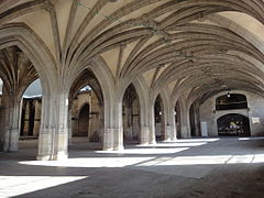 Cloister of the cathedral, Condom
 -
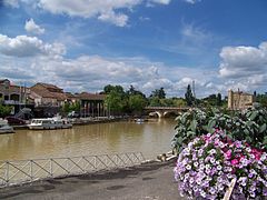 Port of Condom on the Baïse river
 -
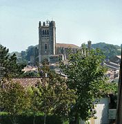 Cathedral of Saint Pierre in Condom


Sister cities[change | change source]
Condom is twinned with:[6]
 Grünberg, Hesse, Germany
 Toro, Castile and León, Spain
Related pages[change | change source]
References[change | change source]
- ↑ Negre, Ernest (1990). Toponymie generale de la France. Librairie Droz. p. 192. ISBN 978-2-600-02883-7.
- ↑ "La capote colle toujours à la peau de CondomTous les projets ont capoté". SudOuest.fr (in French). Retrieved 2018-02-12.
- ↑ "Condom". Map-France.com. Retrieved 24 June 2014.
- ↑ "Condom (32100)" (in French). habitants.fr. Retrieved 24 June 2014.
- ↑ "Régions, départements, arrondissements, cantons et communes" (PDF). Populations légales 2014 (in French). Institut national de la statistique et des études économiques - INSEE. Retrieved 7 March 2017.
- ↑ "Relations internationales" (in French). Condom: City Council website. Archived from the original on 25 September 2013. Retrieved 24 June 2014.
Other websites[change | change source]
- City Council website (in French)
- Office de Tourisme - Condom/La Ténarèze (in French)