
Conway County, Arkansas
Conway County | |
|---|---|
      Clockwise from top: Conway County Courthouse, the Arkansas River, Cedar Falls, a panoramic view of the Arkansas River Valley from Petit Jean State Park, the Morrilton Train Station, and downtown Morrilton | |
 Location within the U.S. state of Arkansas | |
 Arkansas's location within the U.S. | |
| Coordinates: 35°16′00″N 92°42′00″W / 35.2667°N 92.7°W | |
| Country | |
| State | |
| Founded | October 20, 1825 |
| Named for | Henry Wharton Conway |
| Seat | Morrilton |
| Largest city | Morrilton |
| Area | |
| • Total | 566.66 sq mi (1,467.6 km2) |
| • Land | 556.15 sq mi (1,440.4 km2) |
| • Water | 10.51 sq mi (27.2 km2) 1.8% |
| Population | |
| • Total | 20,715 |
| • Density | 37/sq mi (14/km2) |
| Time zone | UTC−6 (Central) |
| • Summer (DST) | UTC−5 (CDT) |
| Website | conwaycountyar |
Conway County is a county of the U.S. state of Arkansas. As of the 2020 census, the population was 20,715.[1] The county seat is Morrilton.[2] It was founded on October 20, 1825.
References[change | change source]
- ↑ 1.0 1.1 "QuickFacts: Conway County, Arkansas". United States Census Bureau. Retrieved August 8, 2023.
- ↑ "Find a County". National Association of Counties. Archived from the original on 2011-05-31. Retrieved 2011-06-07.
Municipalities and communities of Conway County, Arkansas, United States | ||
|---|---|---|
| Cities | 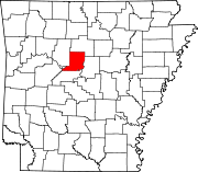 | |
| Town | ||
| CDPs | ||
| Other unincorporated communities | ||
