Creußen
Creußen | |
|---|---|
 Panorama view of Creußen | |
| Coordinates: 49°50′38.35″N 11°37′21.63″E / 49.8439861°N 11.6226750°E | |
| Country | Germany |
| State | Bavaria |
| Admin. region | Oberfranken |
| District | Bayreuth |
| Municipal assoc. | Creußen |
| Government | |
| • Mayor (2020–26) | Martin Dannhäußer[1] |
| Area | |
| • Total | 64.89 km2 (25.05 sq mi) |
| Highest elevation | 640 m (2,100 ft) |
| Lowest elevation | 426 m (1,398 ft) |
| Population (2022-12-31)[2] | |
| • Total | 5,027 |
| • Density | 77/km2 (200/sq mi) |
| Time zone | UTC+01:00 (CET) |
| • Summer (DST) | UTC+02:00 (CEST) |
| Postal codes | 95473 |
| Dialling codes | 09270 |
| Vehicle registration | BT |
| Website | www.stadt-creussen.de |
Creußen is a town in the district of Bayreuth in Bavaria, Germany. It is on the Red Main river, 13 km southeast of Bayreuth.


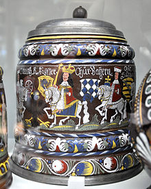
Creußen is famous for its stoneware beer steins.
Notable people[change | change source]
- Christoph Wirth (1870–1950), German physicist and inventor
Wikimedia Commons has media related to Creußen.
References[change | change source]
- ↑ Liste der ersten Bürgermeister/Oberbürgermeister in kreisangehörigen Gemeinden, Bayerisches Landesamt für Statistik, 15 July 2021.
- ↑ Genesis Online-Datenbank des Bayerischen Landesamtes für Statistik Tabelle 12411-003r Fortschreibung des Bevölkerungsstandes: Gemeinden, Stichtag (Einwohnerzahlen auf Grundlage des Zensus 2011)


