Danbury, Connecticut
(Redirected from Danbury)
Danbury, Connecticut | |
|---|---|
City | |
 | |
| Nickname: The Hat City | |
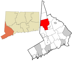
 Danbury's location within Fairfield County and Connecticut | |
| Coordinates: 41°24′08″N 73°28′16″W / 41.40222°N 73.47111°W | |
| Country | United States |
| U.S. state | Connecticut |
| County | Fairfield |
| Incorporated (town) | 1702 |
| Incorporated (city) | 1889 |
| Consolidated | 1965 |
| Area | |
| • City | 44.19 sq mi (114.45 km2) |
| • Land | 41.95 sq mi (108.64 km2) |
| • Water | 2.24 sq mi (5.81 km2) |
| • Urban | 123.6 sq mi (320.1 km2) |
| Elevation | 397 ft (121 m) |
| Population (2020)[2] | |
| • City | 86,518 |
| • Density | 2,062.4/sq mi (779.56/km2) |
| Time zone | UTC−5 (Eastern) |
| • Summer (DST) | UTC−4 (Eastern) |
| ZIP Codes | 06810–06811, 06813 |
| Area code(s) | 203/475 |
| FIPS code | 09-18430 |
| GNIS feature ID | 206580 |
| Major highways | |
| Website | www |
Danbury is a city in Fairfield County, Connecticut, United States. It is 50 miles (80 km) northeast of New York City making it part of the New York metropolitan area. Danbury's population at the 2020 census was 86,518.[2]
The city is named for Danbury in Essex, England.[3] It is nicknamed the "Hat City".
References[change | change source]
- ↑ "2019 U.S. Gazetteer Files". United States Census Bureau. Retrieved July 2, 2020.
- ↑ 2.0 2.1 "QuickFacts: Danbury city, Connecticut". U.S. Census Bureau. Retrieved August 3, 2023.
- ↑ The Connecticut Magazine: An Illustrated Monthly. Connecticut Magazine Company. 1903. p. 331.


