Drachselsried
Drachselsried | |
|---|---|
 Drachselsried | |
| Coordinates: 49°6′N 13°1′E / 49.100°N 13.017°E | |
| Country | Germany |
| State | Bavaria |
| Admin. region | Niederbayern |
| District | Regen |
| Government | |
| • Mayor (2020–26) | Johannes Vogl[1] (CSU) |
| Area | |
| • Total | 41.73 km2 (16.11 sq mi) |
| Highest elevation | 1,284 m (4,213 ft) |
| Lowest elevation | 435 m (1,427 ft) |
| Population (2022-12-31)[2] | |
| • Total | 2,451 |
| • Density | 59/km2 (150/sq mi) |
| Time zone | UTC+01:00 (CET) |
| • Summer (DST) | UTC+02:00 (CEST) |
| Postal codes | 94256 |
| Dialling codes | 09945 |
| Vehicle registration | REG |
| Website | www |
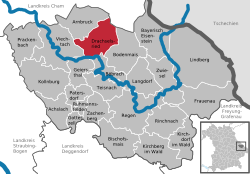
Drachselsried is a municipality in Regen, in Bavaria, Germany. Drachselsried is in the Zeller Valley (German: Zellertal), and is part of the Glass Road (Glasstrasse) The area is part of the Bavarian Forest National Park.
References[change | change source]
- ↑ Liste der ersten Bürgermeister/Oberbürgermeister in kreisangehörigen Gemeinden, Bayerisches Landesamt für Statistik, 15 July 2021.
- ↑ Genesis Online-Datenbank des Bayerischen Landesamtes für Statistik Tabelle 12411-003r Fortschreibung des Bevölkerungsstandes: Gemeinden, Stichtag (Einwohnerzahlen auf Grundlage des Zensus 2011)
Other websites[change | change source]
- https://www.drachselsried.eu Archived 2022-01-17 at the Wayback Machine


