Dyess, Arkansas
Dyess, Arkansas | |
|---|---|
 Dyess Town Hall | |
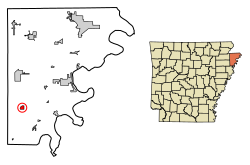
 Location in Mississippi County, Arkansas | |
| Coordinates: 35°35′22″N 90°12′48″W / 35.58944°N 90.21333°W | |
| Country | United States |
| State | Arkansas |
| County | Mississippi |
| Area | |
| • Total | 0.96 sq mi (2.49 km2) |
| • Land | 0.96 sq mi (2.49 km2) |
| • Water | 0.00 sq mi (0.00 km2) |
| Elevation | 223 ft (68 m) |
| Population | |
| • Total | 339 |
| • Density | 352.76/sq mi (136.25/km2) |
| Time zone | UTC-6 (Central (CST)) |
| • Summer (DST) | UTC-5 (CDT) |
| ZIP code | 72330 |
| Area code | 870 |
| FIPS code | 05-20230 |
| GNIS feature ID | 2406409[2] |
Dyess is a town in the US state of Arkansas.
References[change | change source]
- ↑ "2021 U.S. Gazetteer Files: Arkansas". United States Census Bureau. Retrieved June 21, 2022.
- ↑ 2.0 2.1 U.S. Geological Survey Geographic Names Information System: Dyess, Arkansas
- ↑ "P1. Race – Dyess town, Arkansas: 2020 DEC Redistricting Data (PL 94-171)". U.S. Census Bureau. Retrieved June 21, 2022.

