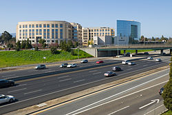
East Palo Alto, California
East Palo Alto, California | |
|---|---|
 University Circle at University Avenue and U.S. Route 101 | |
| Nickname: E.P.A. | |
 Location of East Palo Alto in San Mateo County, California. | |
| Coordinates: 37°28′1″N 122°8′23″W / 37.46694°N 122.13972°W | |
| Country | United States |
| State | California |
| County | San Mateo |
| Incorporated | July 1, 1983[1] |
| Named for | El Palo Alto |
| Area | |
| • Total | 2.64 sq mi (6.85 km2) |
| • Land | 2.53 sq mi (6.55 km2) |
| • Water | 0.12 sq mi (0.30 km2) |
| Elevation | 20 ft (6 m) |
| Population | |
| • Total | 30,034 |
| • Density | 11,000/sq mi (4,400/km2) |
| Time zone | UTC-8 (PST) |
| • Summer (DST) | UTC-7 (PDT) |
| ZIP code | 94303 |
| Area code | 650 |
| FIPS code | 06-20956 |
| GNIS feature ID | 1658461 |
| Website | www |
East Palo Alto is a city in San Mateo County, California. It shares borders with Menlo Park and Palo Alto.
References[change | change source]
- ↑ "California Cities by Incorporation Date". California Association of Local Agency Formation Commissions. Archived from the original (Word) on November 3, 2014. Retrieved August 25, 2014.
- ↑ "2020 U.S. Gazetteer Files". United States Census Bureau. Retrieved October 30, 2021.
- ↑ "East Palo Alto city, California". census.gov. Retrieved 2022-11-26.


