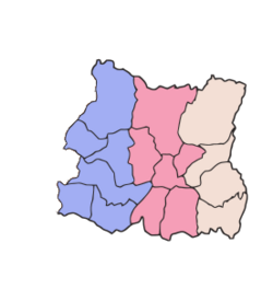
Eastern Development Region, Nepal
पूर्वाञ्चल विकास क्षेत्र
Purwānchal Bikās Kshetra | |
|---|---|
 Location of EDR | |
 | |
| Coordinates: 26°59′N 87°20′E / 26.983°N 87.333°E | |
| Country | |
| Region | Eastern Development Region |
| Established | 1972 |
| Disestablished | 2015 |
| Founded by | King Mahendra |
| Headquarters | Dhankuta, Kosi Zone |
| Largest city | Biratnagar |
| Zones | List
|
| Government | |
| • Type | Regional Administration |
| • Body | Eastern Development Regional Administration |
| Area | |
| • Total | 28,456 km2 (10,987 sq mi) |
| Highest elevation | 8,848 m (29,029 ft) |
| Lowest elevation | 59 m (194 ft) |
| Population (2011 Census) | |
| • Total | 5,811,555 |
| pop. note | |
| Demonym | Purbeli |
| Time zone | UTC+5:45 (NPT) |
| Official language | Nepali |
Eastern Development Region (Nepali: पुर्वाञ्चल विकास क्षेत्र) was one of Nepal's five development regions. It was at the eastern end of the country. Its headquarters were at Dhankuta.
Geography[change | change source]
The Eastern Development Region had Sikkim and West Bengal (India) to the east, Bihar (India) to the south, the Central Development Region to the west and the Tibet Autonomous Region (People's Republic of China) to the north.
The Eastern Region was the third largest Development Region of Nepal with an area of 28,456 square kilometres (10,987 square miles). It was the second in population with 5,811,555 (21.9% of total) people living there in 2011.[1] Its population density was 204.2 persons/km2.
The region had three ecological zones: the high mountains, the hills and the Terai.
The highest mountain in the region, and in the world, is Mount Everest. It is in the Solukhumbu District, Sagarmatha Zone. The lowest point of Nepal, Kechana Kalan is also here, in the Jhapa district. It is near the Mechi river and close to the border with India.
The most important rivers in the Eastern Development Region were the Kosi, tributary of the Ganges river; and the Mechi, tributary of the Mahananda River. Nepal's largest river system (the Kosi) and its highest waterfall (the Hyatrung in the Terhathum district) were found in this region.[2] The Hyatrung waterfall (27°14′17″N 87°33′46″E / 27.23806°N 87.56278°E) is 365 metres (1,198 feet) high.
The region is rich in biodiversity. There are 28 species of Rhododendron (out of the 31 species available in Nepal) in the Tinjure-Milke-Jaljale area.[2]
Cities[change | change source]
The major cities of this region were Biratnagar, Dharan, Dhankuta, Itahari, Rajbiraj, Birtamod Urlabari and Damak. Other notable places are Namche Bazaar (the town near the base camp of Mt. Everest), Gaighat, Lahan, Ilam, etc.
Administrative subdivisions[change | change source]
The Eastern Development Region had 3 Zones, parallel to each other, with a total of 16 Districts, 893 Village Development Committees (VDCs), 1 Sub-metropolitan city, and 13 Municipalities;[2] the zones and districts were:
| Zone | Population[3] (2011) |
Area[4] (km²) |
Pop. density (inh/km²) |
Districts | |
|---|---|---|---|---|---|
| Number | Names | ||||
| Kosi | 2,335,047 | 9,669 | 241.5 | 6 | Bhojpur, Dhankuta, Morang, Sankhuwasabha, Sunsari, Terhathum |
| Mechi | 1,422,182 | 8,196 | 173.5 | 4 | Ilam, Jhapa, Panchthar, Taplejung |
| Sagarmatha | 2,054,326 | 10,591 | 194.0 | 6 | Khotang, Okhaldhunga, Saptari, Siraha, Solukhumbu, Udayapur |
| Total | 5,811,555 | 28,456 | 204.2 | 16 | |
References[change | change source]
- ↑ "National Population and Housing Census 2011" (PDF). Central Bureau of Statistics. Kathmandu, Nepal. November 2012. Archived from the original (pdf) on 7 January 2019. Retrieved 12 October 2013.
- ↑ 2.0 2.1 2.2 "An overview of the Eastern Region of Nepal" (pdf). Biratnagar, Nepal: United Nations Nepal Information Platform. 14 March 2013. Retrieved 26 October 2013.[permanent dead link]
- ↑ "Nepal: Administrative Division". City Population. Retrieved 12 October 2013.
- ↑ "Regions of Nepal". Statoids. 2012-12-07. Retrieved 12 October 2013.
5. growing dental services in kathmandu
