
Fajardo, Puerto Rico
(Redirected from Fajardo)
Fajardo, Puerto Rico | |
|---|---|
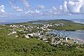
 Aerial view of Fajardo's basin | |
 Flag | |
| Nickname(s): "Los Cariduros", "La Metrópolis del Sol Naciente" | |
| Anthem: "Fajardo que aquí en el oriente" | |
 Location of Fajardo in Puerto Rico | |
| Coordinates: 18°19′33″N 65°39′09″W / 18.32583°N 65.65250°W | |
| Country | United States |
| Territory | Puerto Rico |
| Founded | 1772 |
| Government | |
| • Mayor | Hon. Aníbal Meléndez Rivera (NPP) |
| • Senatorial dist. | 8 - Carolina |
| • Representative dist. | 36 |
| Area | |
| • Total | 60.41 sq mi (156.45 km2) |
| • Land | 31 sq mi (81 km2) |
| • Water | 29.13 sq mi (75.45 km2) |
| Population (2010) | |
| • Total | 36,993 |
| • Density | 610/sq mi (240/km2) |
| Demonym | Fajardeños |
| Time zone | UTC-4 (AST) |
| Zip Code | 00738, 00740 |
Fajardo (fah-HAHR-do) is a small city in eastern Puerto Rico. It is on the Atlantic Ocean, north of Ceiba and east of Luquillo. Fajardo has 7 wards and Fajardo Pueblo (The downtown area and the administrative center of the city).
Photo gallery[change | change source]
-
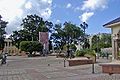 Fajado Plaza
 -
 El Conquistador
 -
 Palomino Island
 -
 Las Croabas


Other websites[change | change source]
- Map of Fajardo Puerto Rico Archived 2007-12-17 at the Wayback Machine