Farmingdale, New York
Farmingdale, New York | |
|---|---|
| Incorporated Village of Farmingdale | |
 Panoramic map of Farmingdale from 1925, with a list of landmarks and several images in the insets at the bottom. | |
| Nickname(s): "Farmingdale Village"; "The Village" | |
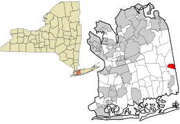
 Location in Nassau County and the state of New York. | |
| Coordinates: 40°44′0″N 73°26′42″W / 40.73333°N 73.44500°W | |
| Country | |
| State | |
| County | Nassau |
| Town | Oyster Bay |
| Incorporated | 1904 |
| Area | |
| • Total | 1.09 sq mi (2.83 km2) |
| • Land | 1.09 sq mi (2.83 km2) |
| • Water | 0.00 sq mi (0.00 km2) |
| Elevation | 69 ft (21 m) |
| Population | |
| • Total | 8,466 |
| • Density | 7,738.57/sq mi (2,987.43/km2) |
| Time zone | UTC−5 (Eastern (EST)) |
| • Summer (DST) | UTC−4 (EDT) |
| ZIP Code | 11735 |
| Area codes | 516, 363 |
| FIPS code | 36-25384 |
| GNIS feature ID | 0949918 |
| Website | www |
Farmingdale is an incorporated village on Long Island within the Town of Oyster Bay in Nassau County, New York, United States. The population was 8,466 at the 2020 Census.[2]
References[change | change source]
- ↑ "ArcGIS REST Services Directory". United States Census Bureau. Retrieved September 20, 2022.
- ↑ 2.0 2.1 "QuickFacts: Farmingdale village, New York". United States Census Bureau. Retrieved March 10, 2024.
Other websites[change | change source]
- Farmingdale official website
- Village history Archived 2008-01-28 at the Wayback Machine


