
File:2020 US House Election Results.svg

Size of this PNG preview of this SVG file: 800 × 379 pixels. Other resolutions: 320 × 152 pixels | 640 × 303 pixels | 1,024 × 485 pixels | 1,280 × 607 pixels | 2,560 × 1,214 pixels | 1,521 × 721 pixels.
Original file (SVG file, nominally 1,521 × 721 pixels, file size: 2.23 MB)
| This is a file from the Wikimedia Commons. Information from its description page there is shown below. Commons is a freely licensed media file repository. You can help. |
Summary
| Description |
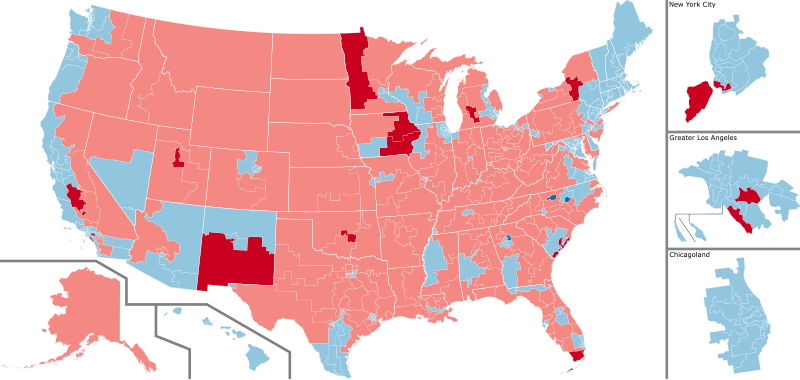
English: A map of the US house districts, color coded by party affiliation of the winner, with information on whether the seat was flipped (darker color) or is still uncalled (grey).
Democratic hold
Republican hold Democratic gain
Republican gain Results and uncalled races per the New York Times, current as of last edit |
| Date | |
| Source | Own work |
| Author | Infinitesimall |
Licensing
| This map is ineligible for copyright and therefore in the public domain, because it consists entirely of information that is common property and contains no original authorship. For more information, see Commons:Threshold of originality § Maps.
|
Though this map is believed to be in the public domain, it was released under the following license:
I, the copyright holder of this work, hereby publish it under the following license:
This file is licensed under the Creative Commons Attribution-Share Alike 4.0 International license.
- You are free:
- to share – to copy, distribute and transmit the work
- to remix – to adapt the work
- Under the following conditions:
- attribution – You must give appropriate credit, provide a link to the license, and indicate if changes were made. You may do so in any reasonable manner, but not in any way that suggests the licensor endorses you or your use.
- share alike – If you remix, transform, or build upon the material, you must distribute your contributions under the same or compatible license as the original.
File history
Click on a date/time to view the file as it appeared at that time.
| Date/Time | Thumbnail | Dimensions | User | Comment | |
|---|---|---|---|---|---|
| current | 20:19, 8 February 2021 | | 1,521 × 721 (2.23 MB) | CoasterEnthusiast18 | Anthony Brindisi conceded, NY-22 flip |
| 00:29, 12 January 2021 |  | 1,521 × 721 (2.23 MB) | Ketrit | AP calls IA-02 for Miller-Meeks. | |
| 23:49, 6 January 2021 |  | 1,521 × 721 (2.23 MB) | Ketrit | Fixed colors and added state borders. | |
| 13:33, 7 December 2020 |  | 512 × 249 (2.53 MB) | DoctorWho70 | The AP and NYT have called NY-1 and NY-2. | |
| 15:20, 2 December 2020 |  | 624 × 303 (2.53 MB) | DoctorWho70 | The Associated Press has called CA-25, NY-11, and NY-24. | |
| 15:10, 2 December 2020 |  | 624 × 303 (2.53 MB) | DoctorWho70 | Reverted to version as of 23:27, 29 November 2020 (UTC) | |
| 15:09, 2 December 2020 |  | 512 × 512 (2.55 MB) | DoctorWho70 | The AP has called CA-21, NY-11, and NY-24. | |
| 23:27, 29 November 2020 |  | 624 × 303 (2.53 MB) | Wollers14 | There can be only updates to the map IF and only IF the AP calls them. The text is different because it requires either an AP call or a concession. The map does not have the concession requirement and only relies on AP calls. | |
| 16:59, 29 November 2020 |  | 624 × 303 (2.53 MB) | Ngfsmg | Reverted to version as of 16:14, 29 November 2020 (UTC) Someone can correct Ca-21 (I don't know how to do it), but we can't have districts called in the text and than say they aren't called in the image | |
| 16:32, 29 November 2020 |  | 624 × 303 (2.53 MB) | Wollers14 | Reverted to version as of 17:36, 28 November 2020 (UTC) You reverted CA 21 and the map will be updated as the AP makes the calls. |
File usage
The following page uses this file:
Global file usage
The following other wikis use this file:
- Usage on bn.wikipedia.org
- Usage on de.wikipedia.org
- Usage on el.wikipedia.org
- Usage on en.wikipedia.org
- Usage on es.wikipedia.org
- Usage on fa.wikipedia.org
- Usage on fi.wikipedia.org
- Usage on fr.wikipedia.org
- Usage on it.wikipedia.org
- Usage on ko.wikipedia.org
- Usage on nl.wikipedia.org
- Usage on pt.wikipedia.org
- Usage on ru.wikipedia.org
- Usage on vi.wikipedia.org
- Usage on zh.wikipedia.org