
File:A Weser watershed closer.gif
A_Weser_watershed_closer.gif (370 × 563 pixels, file size: 9 KB, MIME type: image/gif)
| This is a file from the Wikimedia Commons. Information from its description page there is shown below. Commons is a freely licensed media file repository. You can help. |
Summary
| Description |
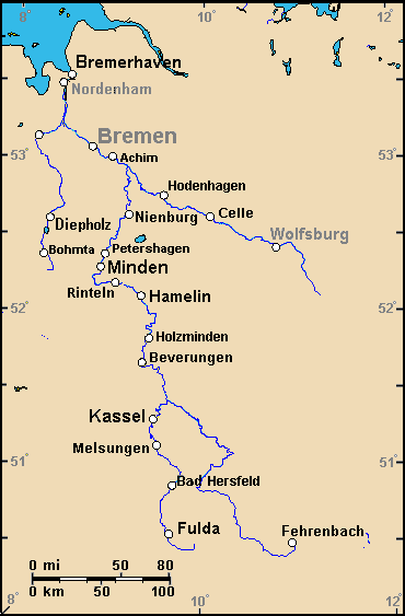
Map of the Weser watershed in northwest Germany, showing largest cities, islands and river names. Large city names (6) have been re-labeled with font-face Arial or Arial Narrow, as font-size 9 or 10; the island/region names are labeled in italic font. Germany contains over 3,500 cities/towns, but they are evenly dispersed around the main towns. This map has locator code "GermanyWeser" for use in map-locator templates, such as English Wiki Template:Location_map_GermanyWeser & Template:Location_map_skew (which skews northern coordinates for multiple map markers / labels, skew=0.91). The latitude/longitude coordinates are NOT equirectangular, with longitudes converging from south to north by 91% closer: the longitudes at bottom range exactly 8-12 degrees, but at top, range 7.75-12.25 degrees apart. The latitude is calibrated for exactly 50-54 degrees N. The original map image has a GFDL license; the extensions are as follows:
|
| Date | |
| Source | Derivative of map (Wikipedia): en:Image:Weser watershed 3.png (enlarging labels, dimming colors to CIA hues & magnified 28%). |
| Author | Wikid77 (derivative of map from WP User:Geo_Swan, cropping & enlarging labels) |
| Other versions |
This map has no variations for Wikimedia, but the original version on Wikipedia:
|
Licensing
| This file is licensed under the Creative Commons Attribution-Share Alike 3.0 Unported license. Subject to disclaimers. | ||
| ||
| This licensing tag was added to this file as part of the GFDL licensing update. |

|
Permission is granted to copy, distribute and/or modify this document under the terms of the GNU Free Documentation License, Version 1.2 or any later version published by the Free Software Foundation; with no Invariant Sections, no Front-Cover Texts, and no Back-Cover Texts. A copy of the license is included in the section entitled GNU Free Documentation License. Subject to disclaimers. |
Map labeling
An online map-creation tool was used to create this map. Here are the longitudes and latitudes of the cities on the map:
- 8.5701, 53.5419 - Bremerhaven
- 8.4750, 53.4848 - Nordenham
- 8.2193, 53.1390 - Oldenburg
- 8.8071, 53.0750 - Bremen
- 9.0255, 53.0128 - Achim
- 9.5835, 52.7622 - Hodenhagen
- 9.9099, 52.6747 - Winsen
- 9.9354, 52.6526 - Oldau
- 9.2147, 52.6334 - Nienburg
- 10.0808, 52.6259 - Celle
- 8.3697, 52.6053 - Diepholz
- 10.7893, 52.4267 - Wolfsburg
- 8.9648, 52.3774 - Petershagen
- 8.3141, 52.3689 - Bohmte
- 8.9224, 52.2904 - Minden
- 8.0808, 52.2769 - Osnabrück
- 8.9226, 52.2395 - Porta Westfalica
- 8.8041, 52.2078 - Bad Oeynhausen
- 9.0802, 52.1878 - Rinteln
- 9.3572, 52.1040 - Hamelin (German: Hameln)
- 9.4449, 51.8277 - Holzminden
- 9.3746, 51.6682 - Beverungen
- 9.5000, 51.3000 - Kassel
- 9.5410, 51.1298 - Melsungen
- 9.7072, 50.8689 - Bad Hersfeld
- 9.6743, 50.5539 - Fulda
- 10.9409, 50.4983 - Fehrenbach
Large, unreadable maps are a rampant problem in Wikimedia, because many maps across the Internet are designed to be huge, like fan-folded roadmaps with tiny lettering. If possible to edit a map, increase font-size of major names to have letters with 1 pixel-thickness for each 200px of map/image width: a 600px-wide image should have lettering 3-pixels thick, or at least "2.5" pixels, with 2 solid pixels + a gray-shade pixel in the lettering. Labels that are only 2-pixels thick on a 600px-wide image become fuzzy, blurred and almost invisible when the image is reduced below 300px width. Most maps out there use the tiny, thin lettering for almost everything, so most maps are thumbnailing with only one word visible and must be edited to enlarge labels. An easy enlargement fix is to crop the map edges, trimming a map to be much less than 600px wide (before resizing), so the cropped image will cause magnified lettering. Rule of thumb: barely readable text can often be clarified by cropping a map only 20% from the left/right edges. A simple trick is to split a wide map in half, as west-side and east-side sections, to quickly double the readability in each half. (Honestly, image-display links should allow a "viewport" zoom-in focus on part of any image, but such an obvious high-tech solution ain't happening anytime soon.)
In general, maps are a hot-topic for debate, because local people don't need to see a map at all, and many articles are expanded by the local people, frustrated at a map in their way; however, newcomers thrive when maps are readable, so perhaps move larger maps near the bottom of an article, where newcomers could still find them. Otherwise, ENLARGE major labels to appear big, when thumbnailed on a tiny map, that local people can skim past. A large annotated map is better when separated as a total image-description page, with multiple paragraphs of explanatory text there, even though explaining a map in an article might, at first, seem a logical way to illustrate major places found on the map. In reality, large maps are rejected by many wiki editors, causing the need for articles of the form "Map of Minnesota" where the concept is obvious that maps, inside the article, will be huge, with the side comments explaining nearby map details. I cannot emphasize enough that many people detest large images in articles, dreaming back to a "wordipedia" containing only words.
Format

This file is purposely maintained in GIF format (most international GIF-related patents have expired) for compatibility with similar CIA maps. Semi-automatic conversions to PNG-format might lose the color hues of the CIA maps, tending to shift to lighter blue and shift beige to white. A larger, detailed version of the map is being expanded, with more of the smaller 3,500 towns added.
File history
Click on a date/time to view the file as it appeared at that time.
| Date/Time | Thumbnail | Dimensions | User | Comment | |
|---|---|---|---|---|---|
| current | 06:43, 6 October 2007 | | 370 × 563 (9 KB) | Wikid77 | enlarged names |
| 23:39, 30 September 2007 |  | 370 × 563 (9 KB) | Wikid77 | == Summary == {{Information | Description=Map of the Weser watershed in northwest Germany, showing largest cities, islands and river names. Large city names (6) have been re-labeled with font-face Arial or Arial Narrow, as font-size 9 or 10; the isla |
File usage
The following 2 pages use this file:
Global file usage
The following other wikis use this file:
- Usage on ar.wikipedia.org
- Usage on ceb.wikipedia.org
- Usage on en.wikipedia.org
- Usage on fa.wikipedia.org
- Usage on kn.wikipedia.org
- Usage on si.wikipedia.org
- Usage on uz.wikipedia.org
- Usage on war.wikipedia.org