
File:Anglo.Saxon.migration.5th.cen.jpg
Original file (1,800 × 1,703 pixels, file size: 875 KB, MIME type: image/jpeg)
| This is a file from the Wikimedia Commons. Information from its description page there is shown below. Commons is a freely licensed media file repository. You can help. |

|
This historical map image could be re-created using vector graphics as an SVG file. This has several advantages; see Commons:Media for cleanup for more information. If an SVG form of this image is available, please upload it and afterwards replace this template with
{{vector version available|new image name}}.
It is recommended to name the SVG file “Anglo.Saxon.migration.5th.cen.svg”—then the template Vector version available (or Vva) does not need the new image name parameter. |


Summary
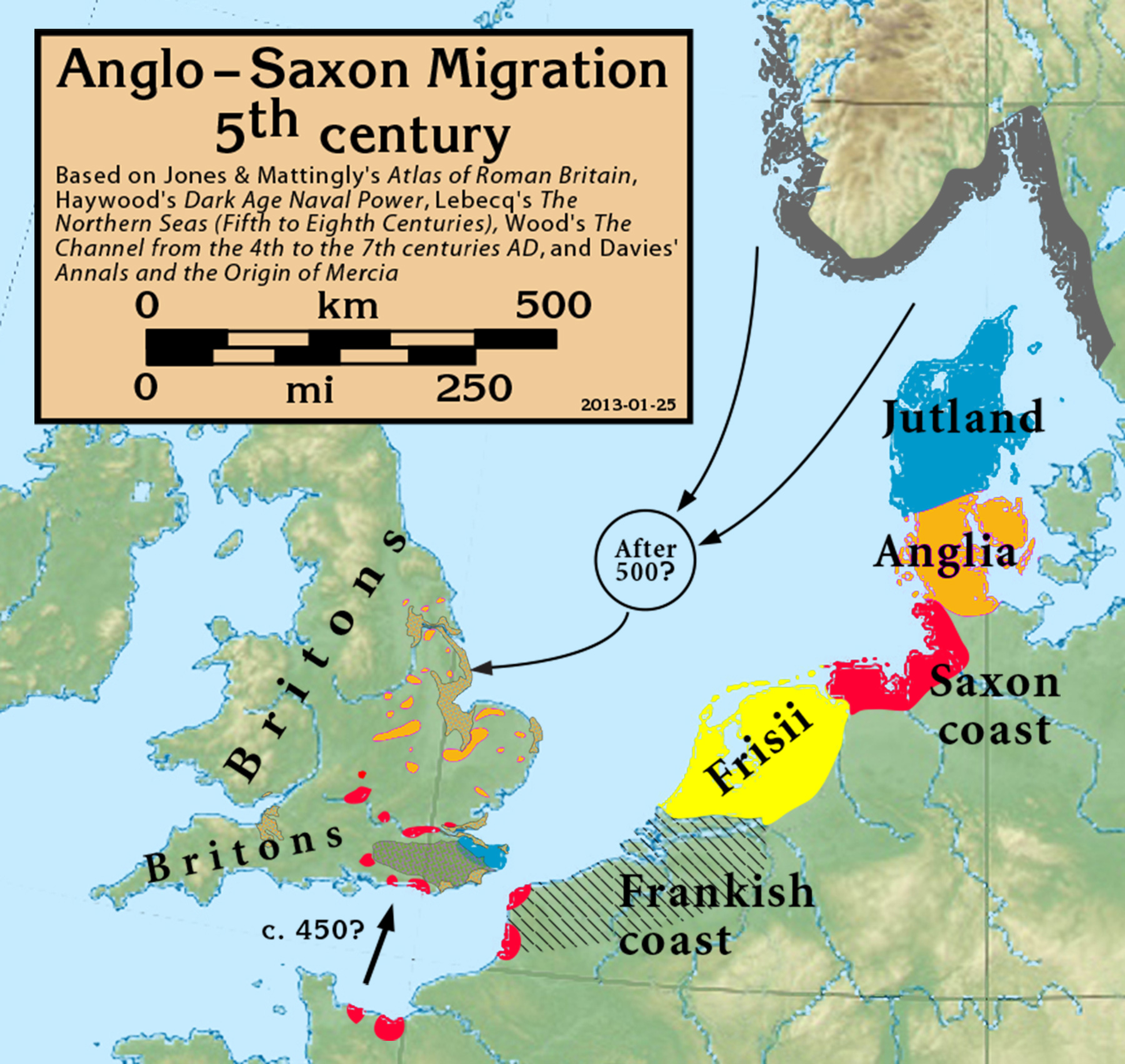
| Description | Anglo-Saxon Migration in the 5th century |
| Date | |
| Source |
Based on Jones & Mattingly's Atlas of Roman Britain (ISBN 978-1-84217-06700, 1990, reprinted 2007, pp. 317, 318), Haywood's Dark Age Naval Power (ISBN 1-898281-43-2, 1999, cemeteries on pp. 84–86, 121, region of "Romanisation" on p. 151), Lebecq's The Northern Seas (fifth to eighth centuries) (in The New Cambridge Medieval History, Vol I c.500–c.700, ISBN 13-978-0-521-36291-7, 2005, p. 643), and Wood's The Channel from the 4th to the 7th centuries AD in Carver's Maritime Celts, Frisians and Saxons (ISBN 978-0906780930, pp 93–97). The suggestion that settlements in Britain were made from the Bessin is from Haywood (Vron, for example, was abandoned c. 450). Jones & Mattingly also show 5th century cemeteries in the central English Midlands south of the River Trent, based on the dating of excavated cemeteries, but this is disputed by historians arguing for a 6th century Anglo-Saxon expansion into that region (see, for example Annals and the Origin of Mercia, pp. 20–24, by Wendy Davies, in Mercian Studies, 1977, ISBN 0718511484).
|
| Author | my work |
Licensing
- You are free:
- to share – to copy, distribute and transmit the work
- to remix – to adapt the work
- Under the following conditions:
- attribution – You must give appropriate credit, provide a link to the license, and indicate if changes were made. You may do so in any reasonable manner, but not in any way that suggests the licensor endorses you or your use.
- share alike – If you remix, transform, or build upon the material, you must distribute your contributions under the same or compatible license as the original.
File history
Click on a date/time to view the file as it appeared at that time.
| Date/Time | Thumbnail | Dimensions | User | Comment | |
|---|---|---|---|---|---|
| current | 17:05, 27 September 2021 | | 1,800 × 1,703 (875 KB) | GPinkerton | Reverted to version as of 16:39, 25 January 2013 (UTC) COM:CROP |
| 15:57, 19 May 2020 |  | 1,800 × 1,703 (885 KB) | Claude Zygiel | Shoreline (high tide) of this time + Flevo lake (the british bank of North Sea was lower but in tectonic rise, the continental bank was upper but in subsidence) | |
| 16:39, 25 January 2013 |  | 1,800 × 1,703 (875 KB) | Notuncurious | minor cleanup and improvement | |
| 20:29, 24 January 2013 |  | 2,635 × 2,451 (932 KB) | Notuncurious | User created page with UploadWizard |
File usage
The following page uses this file:
Global file usage
The following other wikis use this file:
- Usage on ar.wikipedia.org
- Usage on arz.wikipedia.org
- Usage on azb.wikipedia.org
- Usage on br.wikipedia.org
- Usage on ca.wikipedia.org
- Usage on cs.wikipedia.org
- Usage on de.wikipedia.org
- Usage on en.wikipedia.org
- Usage on es.wikipedia.org
- Usage on et.wikipedia.org
- Usage on eu.wikipedia.org
- Usage on fi.wikipedia.org
- Usage on fr.wikipedia.org
- Usage on fy.wikipedia.org
- Usage on ga.wikipedia.org
- Usage on he.wikipedia.org
- Usage on hr.wikipedia.org
- Usage on hu.wikipedia.org
- Usage on hy.wikipedia.org
- Usage on id.wikipedia.org
- Usage on it.wikipedia.org
- Usage on mk.wikipedia.org
- Usage on ms.wikipedia.org
- Usage on nl.wikipedia.org
- Usage on pl.wikipedia.org
- Usage on pt.wikipedia.org
- Usage on ru.wikipedia.org
- Usage on sh.wikipedia.org
- Usage on sk.wikipedia.org
- Usage on sl.wikipedia.org
- Usage on sr.wikipedia.org
View more global usage of this file.