
File:Arrondissement Huy Belgium Map.png
No higher resolution available.
Arrondissement_Huy_Belgium_Map.png (290 × 220 pixels, file size: 7 KB, MIME type: image/png)
| This is a file from the Wikimedia Commons. Information from its description page there is shown below. Commons is a freely licensed media file repository. You can help. |
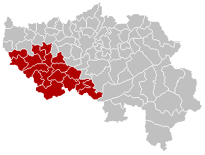
Summary
- EN
- Map of Huy District in province of Liège, Belgium
- FR
- Carte indiquant la localisation de l'arrondissement de Huy dans la Province de Liège.
- WA
- Mape des comenes del province di Lidje, avou l' arondixhmint d' Hu e rodje.

|
File:Arrondissement Huy Belgium Map.svg is a vector version of this file. It should be used in place of this PNG file when not inferior.
File:Arrondissement Huy Belgium Map.png → File:Arrondissement Huy Belgium Map.svg
For more information, see Help:SVG. |
 |
Licensing
| This work has been released into the public domain by its author, LennartBolks. This applies worldwide. In some countries this may not be legally possible; if so: |
File history
Click on a date/time to view the file as it appeared at that time.
| Date/Time | Thumbnail | Dimensions | User | Comment | |
|---|---|---|---|---|---|
| current | 13:02, 24 September 2005 | | 290 × 220 (7 KB) | Srtxg | EN; Map of Huy District in province of Liège, Belgium FR; Carte indiquant la localisation de l'arrondissement de Huy dans la Province de Liège. WA; Mape des comenes del province di Lidje, avou l' arondixhmint d' Hu e rodje. [[Category:Maps of provinc |
File usage
The following page uses this file:
Global file usage
The following other wikis use this file:
- Usage on ar.wikipedia.org
- Usage on ast.wikipedia.org
- Usage on bg.wikipedia.org
- Usage on br.wikipedia.org
- Usage on bs.wikipedia.org
- Usage on cs.wikipedia.org
- Usage on de.wikipedia.org
- Usage on en.wikipedia.org
- Usage on es.wikipedia.org
- Usage on et.wikipedia.org
- Usage on eu.wikipedia.org
- Usage on fa.wikipedia.org
- Usage on fi.wikipedia.org
- Usage on frr.wikipedia.org
- Usage on fr.wikipedia.org
- Usage on hr.wikipedia.org
- Usage on hu.wikipedia.org
- Usage on id.wikipedia.org
- Usage on it.wikipedia.org
- Usage on lb.wikipedia.org
- Usage on li.wikipedia.org
- Usage on lv.wikipedia.org
- Usage on mk.wikipedia.org
- Usage on nl.wikipedia.org
- Usage on no.wikipedia.org
- Usage on pcd.wikipedia.org
- Usage on pt.wikipedia.org
- Usage on ru.wikipedia.org
- Usage on sh.wikipedia.org
- Usage on th.wikipedia.org
- Usage on vec.wikipedia.org
- Usage on vi.wikipedia.org
- Usage on vls.wikipedia.org
- Usage on wa.wikipedia.org
- Usage on www.wikidata.org