
File:Autódromo Oscar y Juan Gálvez Circuito N° 9 xT.svg

Size of this PNG preview of this SVG file: 679 × 600 pixels. Other resolutions: 272 × 240 pixels | 543 × 480 pixels | 869 × 768 pixels | 1,159 × 1,024 pixels | 2,319 × 2,048 pixels | 1,200 × 1,060 pixels.
Original file (SVG file, nominally 1,200 × 1,060 pixels, file size: 194 KB)
| This is a file from the Wikimedia Commons. Information from its description page there is shown below. Commons is a freely licensed media file repository. You can help. |
Summary
| Description |
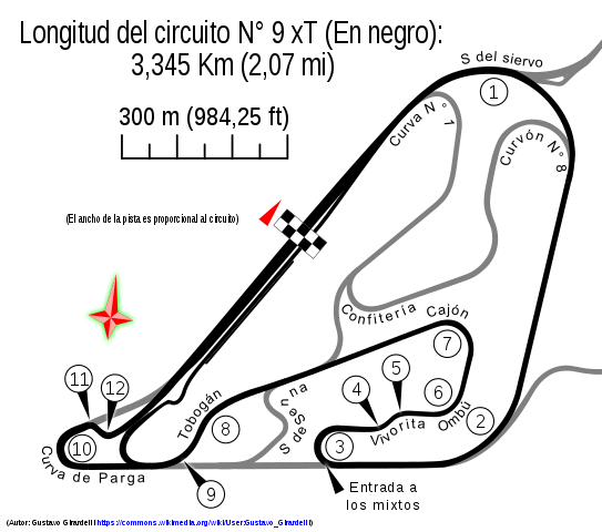
Español: Circuito N° 9 del Autódromo Oscar y Juan Gálvez por Tobogán, calcado de OpenStreetMap con adiciones propias. |
|||
| Date | ||||
| Source |
This W3C-unspecified vector image was created with Inkscape . W3C-validity not checked. |
|||
| Author | Gustavo Girardelli | |||
| Other versions |
W3C-validity not checked.
|
.svg)
.svg)
_(Hist%C3%B3rico).svg)
.svg)


.svg)


_blanco.svg)
| Camera location | | View this and other nearby images on: OpenStreetMap |
|---|

Licensing
I, the copyright holder of this work, hereby publish it under the following license:
This file is licensed under the Creative Commons Attribution-Share Alike 4.0 International license.
- You are free:
- to share – to copy, distribute and transmit the work
- to remix – to adapt the work
- Under the following conditions:
- attribution – You must give appropriate credit, provide a link to the license, and indicate if changes were made. You may do so in any reasonable manner, but not in any way that suggests the licensor endorses you or your use.
- share alike – If you remix, transform, or build upon the material, you must distribute your contributions under the same or compatible license as the original.
File history
Click on a date/time to view the file as it appeared at that time.
| Date/Time | Thumbnail | Dimensions | User | Comment | |
|---|---|---|---|---|---|
| current | 05:29, 16 September 2014 | | 1,200 × 1,060 (194 KB) | Gustavo Girardelli | Nueva versión basada en áreas. |
| 17:32, 2 September 2014 |  | 1,600 × 1,060 (170 KB) | Gustavo Girardelli | User created page with UploadWizard |
File usage
The following page uses this file:
Global file usage
The following other wikis use this file:
- Usage on af.wikipedia.org
- Usage on ar.wikipedia.org
- Usage on bg.wikipedia.org
- Usage on cs.wikipedia.org
- Usage on de.wikipedia.org
- Usage on en.wikipedia.org
- 1972 Argentine Grand Prix
- 1973 Argentine Grand Prix
- Argentine Grand Prix
- Autódromo Oscar y Juan Gálvez
- 1971 Argentine Grand Prix
- 2004 Buenos Aires 200km
- 1968 Buenos Aires Grand Prix
- 1978 Buenos Aires Grand Prix
- 2007 Buenos Aires 200km
- 2008 Buenos Aires Grand Prix Race 2
- 1992 Buenos Aires Grand Prix – World Cup Formula 3000
- 2008 Buenos Aires 200km
- 2009 Buenos Aires Grand Prix Race 1
- 2009 Buenos Aires Grand Prix Race 2
- 2016 Buenos Aires 200km
- Usage on es.wikipedia.org
- Anexo:Gran Premio de Argentina de 1973
- Anexo:Gran Premio de Argentina de 1972
- Anexo:Ronda de Buenos Aires de Turismo Competición 2000 2004
- Anexo:Ronda de Buenos Aires de Turismo Competición 2000 2007
- Anexo:Ronda de Buenos Aires de Turismo Competición 2000 2008
- Anexo:Ronda de Buenos Aires I de Turismo Competición 2000 2005
- Anexo:Ronda de Buenos Aires de Turismo Competición 2000 2003
- Anexo:Ronda de Buenos Aires II de Turismo Competición 2000 2001
- Anexo:Ronda de Buenos Aires de Turismo Competición 2000 2002
- Usage on fa.wikipedia.org
- Usage on fi.wikipedia.org
- Usage on fr.wikipedia.org
- Usage on gl.wikipedia.org
- Usage on id.wikipedia.org
- Usage on it.wikipedia.org
- Usage on ja.wikipedia.org
- Usage on mr.wikipedia.org
View more global usage of this file.