
File:Avebury World Heritage Site map.svg

Size of this PNG preview of this SVG file: 679 × 599 pixels. Other resolutions: 272 × 240 pixels | 544 × 480 pixels | 870 × 768 pixels | 1,160 × 1,024 pixels | 2,320 × 2,048 pixels | 1,614 × 1,425 pixels.
Original file (SVG file, nominally 1,614 × 1,425 pixels, file size: 904 KB)
| This is a file from the Wikimedia Commons. Information from its description page there is shown below. Commons is a freely licensed media file repository. You can help. |
Summary
| Description |
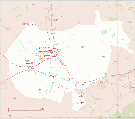
English: Boundary and key sites on the Avebury section of the Stonehenge, Avebury and Associated Sites World Heritage Site |
| Date | |
| Source | OS Open Data with additional material cited at World Heritage Site list No 373 |
| Author | RobinLeicester building on OS OpenData VextorMap District Raster files |
| Camera location | | View this and other nearby images on: OpenStreetMap |
|---|
Licensing
This file is licensed by the Ordnance Survey of the United Kingdom under their OS OpenData License
In short: you are free to distribute and modify the file as long as you attribute (including year), the Ordnance Survey. Attribution: Contains Ordnance Survey data © Crown copyright and database right (year) Note: Derivative works can be licensed under any Creative Commons Attribution 3.0 Licence. |
.svg)
|
This file is licensed under the United Kingdom Open Government Licence v3.0. |
See also: Meta for information on usage on Wikimedia wikis.
|
File history
Click on a date/time to view the file as it appeared at that time.
| Date/Time | Thumbnail | Dimensions | User | Comment | |
|---|---|---|---|---|---|
| current | 01:14, 28 December 2014 | | 1,614 × 1,425 (904 KB) | RobinLeicester | User created page with UploadWizard |
File usage
The following page uses this file:
Global file usage
The following other wikis use this file:
- Usage on en.wikipedia.org
- Usage on fi.wikipedia.org
- Usage on fr.wikipedia.org
- Usage on ja.wikipedia.org
- Usage on kw.wikipedia.org
- Usage on nl.wikipedia.org
- Usage on sl.wikipedia.org
- Usage on vi.wikipedia.org