
File:Battle of Poitiers 1356 map-en.svg

Size of this PNG preview of this SVG file: 696 × 599 pixels. Other resolutions: 279 × 240 pixels | 558 × 480 pixels | 892 × 768 pixels | 1,190 × 1,024 pixels | 2,379 × 2,048 pixels | 1,704 × 1,467 pixels.
Original file (SVG file, nominally 1,704 × 1,467 pixels, file size: 1.64 MB)
| This is a file from the Wikimedia Commons. Information from its description page there is shown below. Commons is a freely licensed media file repository. You can help. |
Summary
| Description |
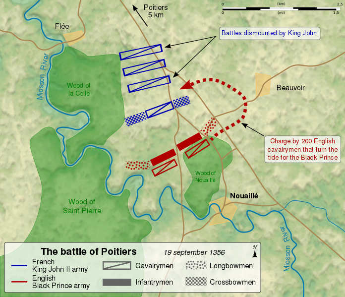
English: Map of the en:Battle of Poitiers (1356), between the French army of King John II and the English army of the Black Prince. Français : Carte de la bataille de Poitiers entre l'armée anglaise du Prince noir Edouard de Woodstock et l'armée du roi de France Jean II. Les deux cents cavaliers cachés dans le bois contournent les lignes françaises et inversent le cours de la bataille, au profit des Anglais. Le roi Jean II de France fait mettre pied-à-terre à ses bataillons de cavalerie, et attend l'assaut. |
||
| Date | (UTC) | ||
| Source |
Own work. Source :
|
||
| Author | Sémhur (talk) | ||
| Other versions |
[]
Derivative works of this file: | ||
| Attribution (required by the license) | © Sémhur / Wikimedia Commons / | ||
| SVG | W3C-validity not checked.
|
||
| Graphic Lab |


| Camera location | | View this and other nearby images on: OpenStreetMap |
|---|
Licensing
I, the copyright holder of this work, hereby publish it under the following licenses:
| Copyleft: This work of art is free; you can redistribute it and/or modify it according to terms of the Free Art License. You will find a specimen of this license on the Copyleft Attitude site as well as on other sites. |
This file is licensed under the Creative Commons Attribution-Share Alike 4.0 International, 3.0 Unported, 2.5 Generic, 2.0 Generic and 1.0 Generic license.
- You are free:
- to share – to copy, distribute and transmit the work
- to remix – to adapt the work
- Under the following conditions:
- attribution – You must give appropriate credit, provide a link to the license, and indicate if changes were made. You may do so in any reasonable manner, but not in any way that suggests the licensor endorses you or your use.
- share alike – If you remix, transform, or build upon the material, you must distribute your contributions under the same or compatible license as the original.
You may select the license of your choice.
File history
Click on a date/time to view the file as it appeared at that time.
| Date/Time | Thumbnail | Dimensions | User | Comment | |
|---|---|---|---|---|---|
| current | 14:52, 27 November 2011 | | 1,704 × 1,467 (1.64 MB) | Sémhur | == {{int:filedesc}} == {{Information |Description={{Multilingual description |en= Map of the en:Battle of Poitiers (1356), between the French army of King John II and the English army of the Black Prince. |fr= Carte de la [[:fr:bataille de Poitiers ( |
File usage
The following page uses this file:
Global file usage
The following other wikis use this file:
- Usage on azb.wikipedia.org
- Usage on da.wikipedia.org
- Usage on et.wikipedia.org
- Usage on hu.wikipedia.org
- Usage on ja.wikipedia.org
- Usage on ko.wikipedia.org
- Usage on lt.wikipedia.org
- Usage on nl.wikipedia.org
- Usage on pt.wikipedia.org
- Usage on uk.wikipedia.org
- Usage on zh.wikipedia.org