
File:Berlin satellite image with Berlin wall.jpg

Size of this preview: 670 × 599 pixels. Other resolutions: 268 × 240 pixels | 537 × 480 pixels | 859 × 768 pixels | 1,145 × 1,024 pixels | 1,506 × 1,347 pixels.
Original file (1,506 × 1,347 pixels, file size: 481 KB, MIME type: image/jpeg)
| This is a file from the Wikimedia Commons. Information from its description page there is shown below. Commons is a freely licensed media file repository. You can help. |
Summary
| Description |
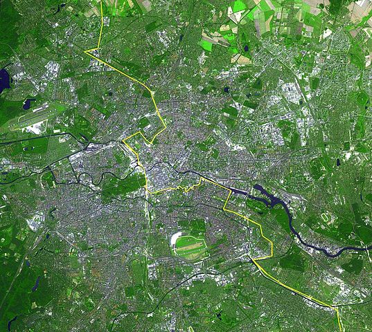
English: Satellite image of Berlin, Germany. The yellow line marks where the Berlin Wall once stood.
This simulated natural color ASTER image covers an area of 22.5 by 20.2 km, and was acquired August 22, 2002. Deutsch: Lage der Berliner Mauer auf einem Satellitenbild,
Gut zu erkennen sind auf diesem Bild aus dem Jahre 2002 die Spree, welche sich horizontal durch die Stadt zieht und der gelb eingezeichnete ehemalige Grenzverlauf zwischen Ost und West. Auffällig sind weiterhin die dichte Bebauung der Berliner Innenstadt innerhalb des S-Bahnrings bzw. der Stadtautobahn, Flughafen Tegel im Nordwesten und Flughafen Tempelhof im Süden, der inmitten der Stadt liegende grüne Tiergarten mit Siegessäule, Messegelände, Tegeler See, Mitte, Spreebogen am Reichstagsgebäude, Lichtenberg, Marzahn und zwei Sportstadien im Osten, Hufeisensiedlung, Britzer Garten südlich des Flughafen Tempelhof...
Español: Situación del Muro de Berlín trazada sobre una fotografía tomada desde un satélite
Slovenčina: Fotografia múru zo satelitu |
|||||
| Date | ||||||
| Source | http://earthobservatory.nasa.gov/Newsroom/NewImages/images.php3?img_id=16417 | |||||
| Author |
English: NASA/GSFC/MITI/ERSDAC/JAROS, and U.S./Japan ASTER Science Team |
|||||
| Permission (Reusing this file) |
|

| Annotations | This image is annotated: View the annotations at Commons |
File history
Click on a date/time to view the file as it appeared at that time.
| Date/Time | Thumbnail | Dimensions | User | Comment | |
|---|---|---|---|---|---|
| current | 00:53, 20 April 2013 | | 1,506 × 1,347 (481 KB) | Webcyss | Borderline corrected |
| 00:53, 20 April 2013 |  | 1,506 × 1,347 (481 KB) | Webcyss | Borderline corrected | |
| 00:37, 20 April 2013 |  | 1,506 × 1,347 (481 KB) | Webcyss | Borderline corrected | |
| 14:09, 13 September 2004 |  | 1,506 × 1,347 (701 KB) | Ed g2s | From http://earthobservatory.nasa.gov/Newsroom/NewImages/images.php3?img_id=16417. {{PD-USGov}} |
File usage
The following page uses this file:
Global file usage
The following other wikis use this file:
- Usage on af.wikipedia.org
- Usage on ast.wikipedia.org
- Usage on ba.wikipedia.org
- Usage on bn.wikipedia.org
- Usage on ca.wikipedia.org
- Usage on de.wikipedia.org
- Usage on diq.wikipedia.org
- Usage on en.wikipedia.org
- Usage on eo.wikipedia.org
- Usage on es.wikipedia.org
- Usage on fa.wikipedia.org
- Usage on fi.wikipedia.org
- Usage on fr.wikipedia.org
- Usage on gl.wikipedia.org
- Usage on gv.wikipedia.org
- Usage on incubator.wikimedia.org
- Usage on kn.wikipedia.org
- Usage on la.wikipedia.org
- Usage on my.wikipedia.org
- Usage on mzn.wikipedia.org
- Usage on nl.wikipedia.org
- Usage on oc.wikipedia.org
- Usage on pa.wikipedia.org
- Usage on pl.wikipedia.org
- Usage on pt.wikipedia.org
- Usage on ro.wikipedia.org
- Usage on ru.wikipedia.org
- Usage on si.wikipedia.org
- Usage on sl.wikipedia.org
- Usage on stq.wikipedia.org
- Usage on ta.wikipedia.org
- Usage on tpi.wikipedia.org
- Usage on vi.wikipedia.org