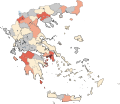
File:COVID-19 Outbreak Cases in Greece per regional unit (prefecture).svg

Size of this PNG preview of this SVG file: 693 × 599 pixels. Other resolutions: 278 × 240 pixels | 555 × 480 pixels | 888 × 768 pixels | 1,184 × 1,024 pixels | 2,369 × 2,048 pixels | 8,460 × 7,315 pixels.
Original file (SVG file, nominally 8,460 × 7,315 pixels, file size: 1.83 MB)
File history
Click on a date/time to view the file as it appeared at that time.
| Date/Time | Thumbnail | Dimensions | User | Comment | |
|---|---|---|---|---|---|
| current | 19:08, 31 March 2020 |  | 8,460 × 7,315 (1.83 MB) | Nikospag | Rethimno and Pella were missing |
| 18:25, 31 March 2020 |  | 8,460 × 7,315 (1.83 MB) | Geraki | update per 29 March | |
| 13:06, 28 March 2020 |  | 8,460 × 7,315 (1.83 MB) | Geraki | Δράμα, Ικαρία, Κεφαλονιά | |
| 16:39, 26 March 2020 |  | 8,460 × 7,315 (1.83 MB) | Geraki | as per 25-03-2020 | |
| 15:35, 24 March 2020 |  | 8,460 × 7,315 (1.82 MB) | Geraki | update for 23-03-2020 - new color scheme | |
| 18:20, 22 March 2020 |  | 8,460 × 7,315 (1.82 MB) | Geraki | per the official report of 20 March | |
| 15:51, 20 March 2020 |  | 8,460 × 7,315 (1.82 MB) | Geraki | διόρθωση Ξάνθη όχι Δράμα | |
| 15:49, 20 March 2020 |  | 8,460 × 7,315 (1.82 MB) | Geraki | Καβάλας, Ξάνθης και Λακωνίας. | |
| 18:44, 19 March 2020 |  | 8,460 × 7,315 (1.82 MB) | Geraki | + Κάρπαθος | |
| 18:37, 19 March 2020 |  | 8,460 × 7,315 (1.82 MB) | Geraki | + Χανιά |
File usage
The following page uses this file:
Global file usage
The following other wikis use this file:
- Usage on bg.wikipedia.org
- Usage on ca.wikipedia.org
- Usage on de.wikipedia.org
- Usage on el.wikipedia.org
- Usage on es.wikipedia.org
- Usage on et.wikipedia.org
- Usage on eu.wikipedia.org
- Usage on fa.wikipedia.org
- Usage on he.wikipedia.org
- Usage on id.wikipedia.org
- Usage on it.wikipedia.org
- Usage on ka.wikipedia.org
- Usage on ko.wikipedia.org
- Usage on lv.wikipedia.org
- Usage on ms.wikipedia.org
- Usage on nl.wikipedia.org
- Usage on pt.wikipedia.org
- Usage on ro.wikipedia.org
- Usage on sq.wikipedia.org
- Usage on su.wikipedia.org
- Usage on tr.wikipedia.org
- Usage on uk.wikipedia.org
- Usage on uz.wikipedia.org
- Usage on vi.wikipedia.org
- Usage on www.wikidata.org
- Usage on zh-yue.wikipedia.org
- Usage on zh.wikipedia.org
