
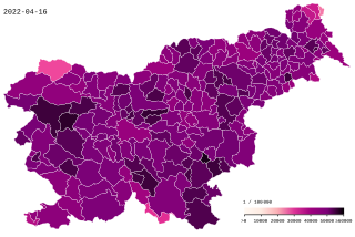
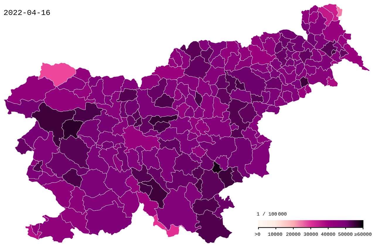
File:COVID-19 Slovenia cases per capita.svg

Size of this PNG preview of this SVG file: 512 × 342 pixels. Other resolutions: 320 × 214 pixels | 640 × 428 pixels | 1,024 × 684 pixels | 1,280 × 855 pixels | 2,560 × 1,710 pixels.
Original file (SVG file, nominally 512 × 342 pixels, file size: 69 KB)
| This is a file from the Wikimedia Commons. Information from its description page there is shown below. Commons is a freely licensed media file repository. You can help. |
Summary
| Description |
English: COVID19 in Slovenia - cumulative positive cases by 100k inhabitants. Gradient steps: >0 10,000 20,000 30,000 40,000 50,000 ≥ 60,000 |
| Data table | Data:COVID-19 Slovenia cases per capita.tab |
| Date | |
| Source |
This vector image includes elements that have been taken or adapted from this file: |
| Author | Xplus1 |
| Other versions | |
| SVG development | This map was created with an unknown SVG tool. |

|
This file may be updated to reflect new information. If you wish to use a specific version of the file without new updates being mirrored, please upload the required version as a separate file. |
Licensing
I, the copyright holder of this work, hereby publish it under the following license:
This file is licensed under the Creative Commons Attribution-Share Alike 4.0 International license.
- You are free:
- to share – to copy, distribute and transmit the work
- to remix – to adapt the work
- Under the following conditions:
- attribution – You must give appropriate credit, provide a link to the license, and indicate if changes were made. You may do so in any reasonable manner, but not in any way that suggests the licensor endorses you or your use.
- share alike – If you remix, transform, or build upon the material, you must distribute your contributions under the same or compatible license as the original.
File history
Click on a date/time to view the file as it appeared at that time.
| Date/Time | Thumbnail | Dimensions | User | Comment | |
|---|---|---|---|---|---|
| current | 16:02, 17 April 2022 | | 512 × 342 (69 KB) | XplusMapBot | data 2022-04-16, 991.309 total, map diff: 557 = 0.06 % |
| 16:02, 16 April 2022 |  | 512 × 342 (69 KB) | XplusMapBot | data 2022-04-15, 990.752 total, map diff: 1302 = 0.13 % | |
| 16:02, 15 April 2022 |  | 512 × 342 (69 KB) | XplusMapBot | data 2022-04-14, 989.450 total, map diff: 1339 = 0.14 % | |
| 16:02, 14 April 2022 |  | 512 × 342 (69 KB) | XplusMapBot | data 2022-04-13, 988.111 total, map diff: 1651 = 0.17 % | |
| 16:02, 13 April 2022 |  | 512 × 342 (69 KB) | XplusMapBot | data 2022-04-12, 986.460 total, map diff: 1693 = 0.17 % | |
| 16:02, 12 April 2022 |  | 512 × 342 (69 KB) | XplusMapBot | data 2022-04-11, 984.767 total, map diff: 2699 = 0.27 % | |
| 16:02, 11 April 2022 |  | 512 × 342 (69 KB) | XplusMapBot | data 2022-04-10, 982.068 total, map diff: 532 = 0.05 % | |
| 16:02, 10 April 2022 |  | 512 × 342 (69 KB) | XplusMapBot | data 2022-04-09, 981.536 total, map diff: 799 = 0.08 % | |
| 16:02, 9 April 2022 |  | 512 × 342 (69 KB) | XplusMapBot | data 2022-04-08, 980.737 total, map diff: 1866 = 0.19 % | |
| 16:02, 8 April 2022 |  | 512 × 342 (69 KB) | XplusMapBot | data 2022-04-07, 978.871 total, map diff: 2040 = 0.21 % |
File usage
The following page uses this file:
Global file usage
The following other wikis use this file:
- Usage on ar.wikipedia.org
- Usage on ca.wikipedia.org
- Usage on de.wikipedia.org
- Usage on eo.wikipedia.org
- Usage on et.wikipedia.org
- Usage on eu.wikipedia.org
- Usage on fa.wikipedia.org
- Usage on fr.wikipedia.org
- Usage on he.wikipedia.org
- Usage on hu.wikipedia.org
- Usage on id.wikipedia.org
- Usage on it.wikipedia.org
- Usage on ko.wikipedia.org
- Usage on lv.wikipedia.org
- Usage on ms.wikipedia.org
- Usage on pl.wikipedia.org
- Usage on ru.wikipedia.org
- Usage on sl.wikipedia.org
- Usage on tr.wikipedia.org
- Usage on uk.wikipedia.org
- Usage on uz.wikipedia.org
- Usage on vi.wikipedia.org
- Usage on www.wikidata.org
- Usage on zh.wikipedia.org