
File:COVID-19 pandemic cases in Indonesia map (Density).svg

Size of this PNG preview of this SVG file: 512 × 196 pixels. Other resolutions: 320 × 123 pixels | 640 × 245 pixels | 1,024 × 392 pixels | 1,280 × 490 pixels | 2,560 × 980 pixels.
Original file (SVG file, nominally 512 × 196 pixels, file size: 299 KB)
| This is a file from the Wikimedia Commons. Information from its description page there is shown below. Commons is a freely licensed media file repository. You can help. |
.svg)
Summary
| Description |
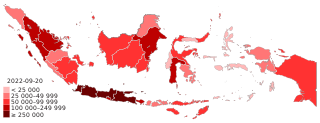
English (en): Map of the COVID-19 pandemic in Indonesia showing confirmed cases by province as of last update on 25 June 2023
<25,000 confirmed cases 25,000–49,999 confirmed cases 50,000–99,999 confirmed cases 100,000–249,999 confirmed cases ≥250,000 confirmed cases
Bahasa Indonesia (id): Peta pandemi Covid-19 di Indonesia menunjukkan kasus terkonfirmasi menurut provinsi sampai pembaruan data terakhir pada tanggal 25 Juni 2023
<25.000 kasus terkonfirmasi 25.000–49.999 kasus terkonfirmasi 50.000–99.999 kasus terkonfirmasi 100.000–249.999 kasus terkonfirmasi ≥250.000 kasus terkonfirmasi
Bahasa Melayu (ms): Peta pandemik COVID-19 di Indonesia memaparkan bilangan kes yang disahkan mengikut wilayah setakat kemaskini muktamad pada 25 Jun 2023
<25.000 kes disahkan 25.000–49.999 kes disahkan 50.000–99.999 kes disahkan 100.000–249.999 kes disahkan ≥250.000 kes disahkan
|
| Date | |
| Source | Own work based on File:Indonesia provinces outline map.svg |
| Author | Danialrosli |
Licensing
I, the copyright holder of this work, hereby publish it under the following license:
This file is licensed under the Creative Commons Attribution-Share Alike 4.0 International license.
- You are free:
- to share – to copy, distribute and transmit the work
- to remix – to adapt the work
- Under the following conditions:
- attribution – You must give appropriate credit, provide a link to the license, and indicate if changes were made. You may do so in any reasonable manner, but not in any way that suggests the licensor endorses you or your use.
- share alike – If you remix, transform, or build upon the material, you must distribute your contributions under the same or compatible license as the original.
File history
Click on a date/time to view the file as it appeared at that time.
.svg&dir=prev)
.svg&offset=20220221055524)
.svg&offset=&limit=20)
.svg&offset=&limit=50)
.svg&offset=&limit=100)
.svg&offset=&limit=250)
.svg&offset=&limit=500)
| Date/Time | Thumbnail | Dimensions | User | Comment | |
|---|---|---|---|---|---|
| current | 01:37, 21 September 2022 | 512 × 196 (299 KB) | Flix11 | fix date | |
| 01:36, 21 September 2022 | 512 × 196 (299 KB) | Flix11 | Papua 50K+ | ||
| 11:47, 10 March 2022 | 512 × 196 (299 KB) | Flix11 | Sulut 50K+ | ||
| 09:58, 7 March 2022 | 512 × 196 (299 KB) | Flix11 | Sultra 25K+ | ||
| 08:41, 4 March 2022 | 512 × 196 (299 KB) | Flix11 | Sumbar 100K+ | ||
| 05:44, 25 February 2022 | 512 × 196 (299 KB) | Flix11 | Kalbar 50K+ | ||
| 01:12, 25 February 2022 | 512 × 196 (299 KB) | Flix11 | Banten 250K+ | ||
| 07:54, 24 February 2022 | 512 × 196 (299 KB) | Flix11 | fix | ||
| 06:44, 23 February 2022 | 512 × 196 (299 KB) | Flix11 | Kalteng, Sulteng 50K+. | ||
| 05:55, 21 February 2022 | 512 × 196 (299 KB) | Flix11 | Bengkulu 25K+ |
File usage
The following page uses this file:
Global file usage
The following other wikis use this file:
- Usage on ar.wikipedia.org
- Usage on bjn.wikipedia.org
- Usage on de.wikipedia.org
- Usage on en.wikipedia.org
- Usage on es.wikipedia.org
- Usage on et.wikipedia.org
- Usage on fa.wikipedia.org
- Usage on fr.wikipedia.org
- Usage on he.wikipedia.org
- Usage on id.wikipedia.org
- Usage on jv.wikipedia.org
- Usage on ko.wikipedia.org
- Usage on min.wikipedia.org
- Usage on ml.wikipedia.org
- Usage on ms.wikipedia.org
- Usage on pt.wikipedia.org
- Usage on ru.wikipedia.org
- Usage on sq.wikipedia.org
- Usage on su.wikipedia.org
- Usage on ta.wikipedia.org
- Usage on th.wikipedia.org
- Usage on tr.wikipedia.org
- Usage on uk.wikipedia.org
- Usage on uz.wikipedia.org
- Usage on www.wikidata.org
- Usage on zh-yue.wikipedia.org
- Usage on zh.wikipedia.org
.svg)