
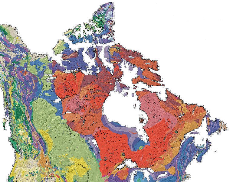
File:Canada geological map.JPG

Size of this preview: 770 × 599 pixels. Other resolutions: 308 × 240 pixels | 617 × 480 pixels | 987 × 768 pixels | 1,280 × 996 pixels | 2,000 × 1,557 pixels.
Original file (2,000 × 1,557 pixels, file size: 2.25 MB, MIME type: image/jpeg)
| This is a file from the Wikimedia Commons. Information from its description page there is shown below. Commons is a freely licensed media file repository. You can help. |

|
This geology image could be re-created using vector graphics as an SVG file. This has several advantages; see Commons:Media for cleanup for more information. If an SVG form of this image is available, please upload it and afterwards replace this template with
{{vector version available|new image name}}.
It is recommended to name the SVG file “Canada geological map.svg”—then the template Vector version available (or Vva) does not need the new image name parameter. |


Summary
| Description |
English: Geological Map of Canada |
| Date | |
| Source | en:File:North america with-Williston.jpg, PD - USGS |
| Author | Qyd |
Licensing
| I, the copyright holder of this work, release this work into the public domain. This applies worldwide. In some countries this may not be legally possible; if so: I grant anyone the right to use this work for any purpose, without any conditions, unless such conditions are required by law. |
File history
Click on a date/time to view the file as it appeared at that time.
| Date/Time | Thumbnail | Dimensions | User | Comment | |
|---|---|---|---|---|---|
| current | 16:23, 6 March 2009 | | 2,000 × 1,557 (2.25 MB) | Qyd | {{Information |Description={{en|1=Geological Map of Canada}} |Source=File:North america with-Williston.jpg, PD - USGS |Author=Qyd |Date=2009 |Permission= |other_versions= }} Category:Maps of Canada <!--{{ImageUpload|full}}--> |
File usage
The following 2 pages use this file:
Global file usage
The following other wikis use this file:
- Usage on be.wikipedia.org
- Usage on bg.wikipedia.org
- Usage on bn.wikipedia.org
- Usage on bs.wikipedia.org
- Usage on cs.wikipedia.org
- Usage on de.wikipedia.org
- Usage on en.wikipedia.org
- Usage on en.wikiversity.org
- Usage on en.wikivoyage.org
- Usage on fa.wikipedia.org
- Usage on fr.wikipedia.org
- Usage on gcr.wikipedia.org
- Usage on he.wikipedia.org
- Usage on he.wiktionary.org
- Usage on hu.wikipedia.org
- Usage on id.wikipedia.org
- Usage on ja.wikipedia.org
- Usage on pl.wikipedia.org
- Usage on ru.wikipedia.org
- Usage on sh.wikipedia.org
- Usage on sk.wikipedia.org
- Usage on uk.wikipedia.org
- Usage on zh-yue.wikipedia.org
- Usage on zh.wikipedia.org