
File:Carte division das reich mai juin 1944.png
Size of this preview: 414 × 600 pixels. Other resolutions: 166 × 240 pixels | 331 × 480 pixels | 923 × 1,337 pixels.
Original file (923 × 1,337 pixels, file size: 31 KB, MIME type: image/png)
| This is a file from the Wikimedia Commons. Information from its description page there is shown below. Commons is a freely licensed media file repository. You can help. |

|
This military map image could be re-created using vector graphics as an SVG file. This has several advantages; see Commons:Media for cleanup for more information. If an SVG form of this image is available, please upload it and afterwards replace this template with
{{vector version available|new image name}}.
It is recommended to name the SVG file “Carte division das reich mai juin 1944.svg”—then the template Vector version available (or Vva) does not need the new image name parameter. |
Summary
| Description |
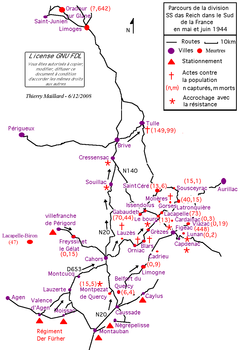
Français : Report sur la carte du parcours de la division SS Das Reich dans le sud de la France en mai et juin 1944 |
| Date | |
| Source | Own work |
| Author | Thierry Maillard |
Document réalisé d'après le Mémoire de Géopolitique du Chef de bataillon Rémy Cadapeaud - Le crime de masse à Oradour-sur-Glane - Collège Interarmées de Défense - mars 2003 - Ouvrage à consulter sur place : à Paris, à la bibliothèque de l'Ecole Militaire (1, place Joffre).
Licensing
I, the copyright holder of this work, hereby publish it under the following licenses:

|
Permission is granted to copy, distribute and/or modify this document under the terms of the GNU Free Documentation License, Version 1.2 or any later version published by the Free Software Foundation; with no Invariant Sections, no Front-Cover Texts, and no Back-Cover Texts. A copy of the license is included in the section entitled GNU Free Documentation License. |
| This file is licensed under the Creative Commons Attribution-Share Alike 3.0 Unported license. | ||
| ||
| This licensing tag was added to this file as part of the GFDL licensing update. |
You may select the license of your choice.
File history
Click on a date/time to view the file as it appeared at that time.
| Date/Time | Thumbnail | Dimensions | User | Comment | |
|---|---|---|---|---|---|
| current | 21:06, 6 December 2008 | | 923 × 1,337 (31 KB) | Thierry46 | |
| 19:31, 30 April 2008 |  | 1,033 × 1,353 (29 KB) | Thierry46 | {{Information |Description=Report sur la carte du parcours de la division SS Das Reich dans le sud de la France en mai et juin 1944 : correction faute de frappe dans légende. |Source=Oeuvre personnelle |Date=30/4/2008 |Author=~~~~ |Permission= |other_ver | |
| 19:27, 30 April 2008 |  | 1,033 × 1,353 (29 KB) | Thierry46 | {{Information |Description=Report sur la carte du parcours de la division SS Das Reich dans le sud de la France en mai et juin 1944 : correction faute de frappe dans légende. |Source=Oeuvre personnelle |Date=30/4/2008 |Author=~~~~ |Permission= |other_ver | |
| 21:31, 5 February 2007 |  | 1,033 × 1,353 (78 KB) | Thierry46 | {{Information |Description=Report sur la carte du parcours de la division SS Das Reich dans le sud de la France en mai et juin 1944 |Source=Oeuvre personnelle |Date=5/2/2007 |Author=Thierry Maillard |Permission=Je me l'accorde |other_versions= }} Documen |
File usage
The following page uses this file:
Global file usage
The following other wikis use this file:
- Usage on ca.wikipedia.org
- Usage on en.wikipedia.org
- Usage on fr.wikipedia.org
- Usage on he.wikipedia.org
- Usage on it.wikipedia.org
- Usage on nl.wikipedia.org
- Usage on pt.wikipedia.org
- Usage on www.wikidata.org