
File:Carte maine.svg

Size of this PNG preview of this SVG file: 800 × 554 pixels. Other resolutions: 320 × 222 pixels | 640 × 443 pixels | 1,024 × 709 pixels | 1,280 × 886 pixels | 2,560 × 1,772 pixels | 1,813 × 1,255 pixels.
Original file (SVG file, nominally 1,813 × 1,255 pixels, file size: 3.76 MB)
| This is a file from the Wikimedia Commons. Information from its description page there is shown below. Commons is a freely licensed media file repository. You can help. |
Summary
| Description |
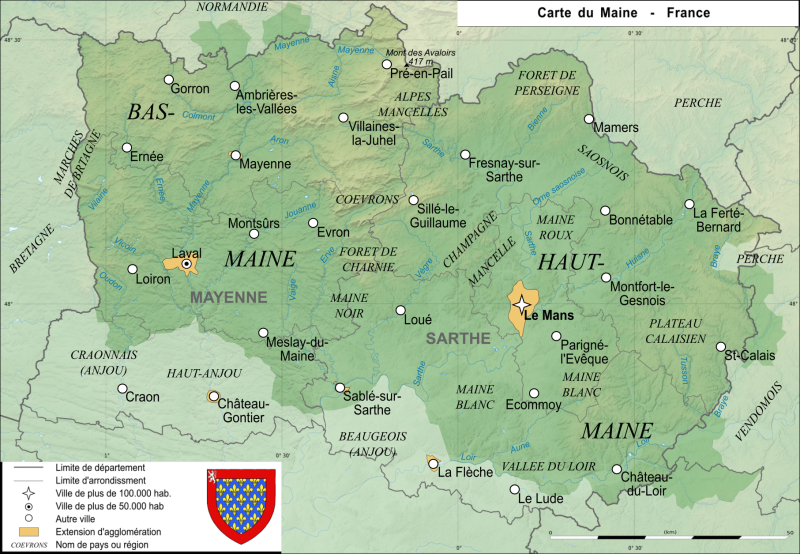
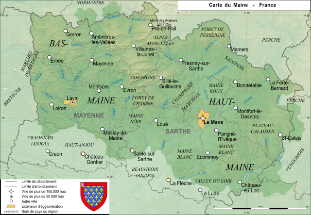
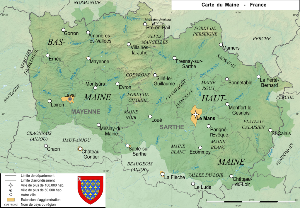
Carte de l'ancienne province française du Maine Map of the ancient french province Maine |
| Date | |
| Source | Own work |
| Author | User:Esprit04 |
Licensing
| I, the copyright holder of this work, release this work into the public domain. This applies worldwide. In some countries this may not be legally possible; if so: I grant anyone the right to use this work for any purpose, without any conditions, unless such conditions are required by law. |
File history
Click on a date/time to view the file as it appeared at that time.
| Date/Time | Thumbnail | Dimensions | User | Comment | |
|---|---|---|---|---|---|
| current | 12:27, 20 August 2021 | | 1,813 × 1,255 (3.76 MB) | Esprit04 | limites |
| 17:23, 5 February 2021 |  | 1,812 × 1,254 (3.41 MB) | Esprit04 | m | |
| 20:32, 4 February 2021 |  | 1,811 × 1,253 (3.38 MB) | Esprit04 | m | |
| 13:21, 1 February 2021 |  | 1,811 × 1,253 (3.38 MB) | Esprit04 | Meilleure version | |
| 21:03, 4 May 2011 |  | 2,816 × 2,112 (64 KB) | VIGNERON | ||
| 11:00, 9 March 2008 |  | 2,816 × 2,112 (72 KB) | Esprit04 | {{Information |Description=Carte de l'ancienne province française du Maine Map of the ancient french province Maine |Source=travail personnel |Date=09/03/2008 |Author= Koostia |Permission= |other_versions= }} Category:Sarthe[[Catego | |
| 10:36, 9 March 2008 |  | 2,816 × 2,112 (72 KB) | Esprit04 | {{Information |Description=Carte de l'ancienne province française du Maine Map of the ancient french province Maine |Source=travail personnel |Date=09/03/2008 |Author= Koostia |Permission= |other_versions= }} Category:Sarthe[[Catego | |
| 10:36, 9 March 2008 |  | 2,816 × 2,112 (72 KB) | Esprit04 | {{Information |Description=Carte de l'ancienne province française du Maine Map of the ancient french province Maine |Source=travail personnel |Date=09/03/2008 |Author= Koostia |Permission= |other_versions= }} Category:Sarthe[[Categor | |
| 10:34, 9 March 2008 |  | 2,816 × 2,112 (72 KB) | Esprit04 | {{Information |Description=Carte de l'ancienne province française du Maine Map of the ancient french province Maine |Source=travail personnel |Date=09/03/2008 |Author= Koostia |Permission= |other_versions= }} Category:Sarthe[[Categor | |
| 10:28, 9 March 2008 |  | 2,816 × 2,112 (72 KB) | Esprit04 | {{Information |Description=Carte de l'ancienne province française du Maine Map of the ancient french province Maine |Source=travail personnel |Date=09/03/2008 |Author= Koostia |Permission= |other_versions= }} Category:Sarthe[[Categor |
File usage
The following page uses this file:
Global file usage
The following other wikis use this file:
- Usage on ca.wikipedia.org
- Usage on de.wikipedia.org
- Usage on en.wikipedia.org
- Usage on es.wikipedia.org
- Usage on fa.wikipedia.org
- Usage on fr.wikipedia.org
- Usage on he.wikipedia.org
- Usage on it.wikipedia.org
- Usage on lfn.wikipedia.org
- Usage on nrm.wikipedia.org
- Usage on pt.wikipedia.org