
File:Contiguous US physiographic divisions.png
Size of this preview: 800 × 525 pixels. Other resolutions: 320 × 210 pixels | 640 × 420 pixels | 1,024 × 672 pixels | 1,264 × 830 pixels.
Original file (1,264 × 830 pixels, file size: 1.1 MB, MIME type: image/png)
| This is a file from the Wikimedia Commons. Information from its description page there is shown below. Commons is a freely licensed media file repository. You can help. |
Summary
| Description |
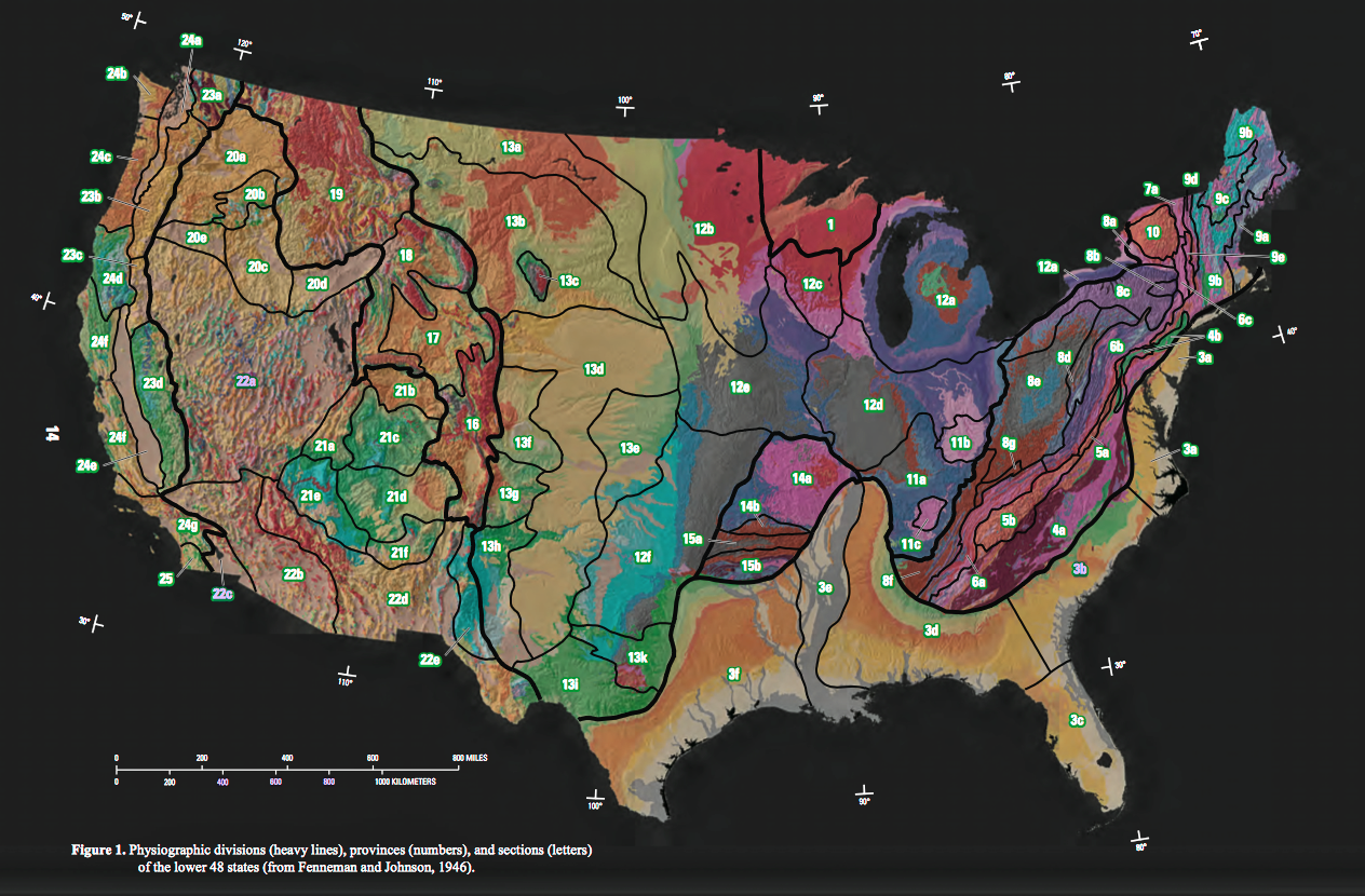
PHYSIOGRAPHIC REGIONS OF THE LOWER 48 UNITED STATES after Fenneman (1928) LAURENTIAN UPLAND 1. Superior Upland ATLANTIC PLAIN 2. Continental Shelf (not on map)
3. Coastal Plain
a. Embayed section
b. Sea Island section
c. Floridian section
d. East Gulf Coastal Plain
e. Mississippi Alluvial Plain
f. West Gulf Coastal Plain
APPALACHIAN HIGHLANDS 4. Piedmont province
a. Piedmont Upland
b. Piedmont Lowlands
5. Blue Ridge province
a. Northern section
b. Southern section
6. Valley and Ridge province
a. Tennessee section
b. Middle section
c. Hudson Valley
7. St. Lawrence Valley
a. Champlain section
b. Northern section (not on map)
8. Appalachian Plateaus province
a. Mohawk section
b. Catskill section
c. Southern New York section
d. Allegheny Mountain section
e. Kanawha section
f. Cumberland Plateau section
g. Cumberland Mountain section
9. New England Province
a. Seaboard Lowland section
b. New England Upland section
c. White Mountain section
d. Green Mountain section
e. Taconic section
10. Adirondack province
INTERIOR PLAINS 11. Interior Low Plateaus
a. Highland Rim section
b. Lexington Plain
c. Nashville Basin
12. Central Lowland
a. Eastern Lake section
b. Western Lake section
c. Wisconsin Driftless section
d. Till Plains
e. Dissected Till Plains
f. Osage Plains
13. Great Plains province
a. Missouri Plateau, glaciated
b. Missouri Plateau, unglaciated
c. Black Hills
d. High Plains
e. Plains Border
f. Colorado Piedmont
g. Raton section
h. Pecos Valley
i. Edwards Plateau
k. Central Texas section
INTERIOR HIGHLANDS 14. Ozark Plateaus
a. Springfield-Salem plateaus
b. Boston “Mountains”
15. Ouachita province
a. Arkansas Valley
b. Ouachita Mountains
ROCKY MOUNTAIN SYSTEM 16. Southern Rocky Mountains 17. Wyoming Basin 18. Middle Rocky Mountains 19. Northern Rocky Mountains INTERMONTANE PLATEAUS 20. Columbia Plateau
a. Walla Walla Plateau
b. Blue Mountain section
c. Payette section
d. Snake River Plain
e. Harney section
21. Colorado Plateaus
a. High Plateaus of Utah
b. Uinta Basin
c. Canyon Lands
d. Navajo section
e. Grand Canyon section
f. Datil section
22. Basin and Range province
a. Great Basin
b. Sonoran Desert
c. Salton Trough
d. Mexican Highland
e. Sacramento section
PACIFIC MOUNTAIN SYSTEM 23. Cascade-Sierra Mountains
a. Northern Cascade Mountains
b. Middle Cascade Mountains
c. Southern Cascade Mountains
d. Sierra Nevada
24. Pacific Border province
a. Puget Trough
b. Olympic Mountains
c. Oregon Coast Range
d. Klamath Mountains
e. California Trough
f. California Coast Ranges
g. Los Angeles Ranges
25. Lower California province |
| Date | |
| Source | A Tapestry of Time and Terrain: Pamphlet to accompany Geologic Investigations Series I–2720[1] |
| Author | José F. Vigil, Richard J. Pike, and David G. Howell |
| Other versions |
|

Licensing
This image is in the public domain in the United States because it only contains materials that originally came from the United States Geological Survey, an agency of the United States Department of the Interior. For more information, see the official USGS copyright policy.
|
File history
Click on a date/time to view the file as it appeared at that time.
| Date/Time | Thumbnail | Dimensions | User | Comment | |
|---|---|---|---|---|---|
| current | 03:25, 7 April 2017 | | 1,264 × 830 (1.1 MB) | Wsiegmund | Photoshop Elements 11: increased saturation, adjusted hue. |
| 02:46, 7 April 2017 |  | 1,264 × 830 (1.17 MB) | Wsiegmund | {{Information |Description=PHYSIOGRAPHIC REGIONS OF THE LOWER 48 UNITED STATES after Fenneman (1928)<br/> <br/> LAURENTIAN UPLAND <br/> 1. Superior Upland<br/> <br/> ATLANTIC PLAIN<br/> 2. Continental Shelf (not on map) <br/> 3. Coastal Plain<br/... |
File usage
The following page uses this file:
Global file usage
The following other wikis use this file:
- Usage on en.wikipedia.org
- Usage on it.wikipedia.org
- Usage on uk.wikipedia.org