
File:Cyclones Lam and Marcia.jpg
Original file (5,914 × 3,943 pixels, file size: 4.43 MB, MIME type: image/jpeg)
| This is a file from the Wikimedia Commons. Information from its description page there is shown below. Commons is a freely licensed media file repository. You can help. |
Summary
| Description |
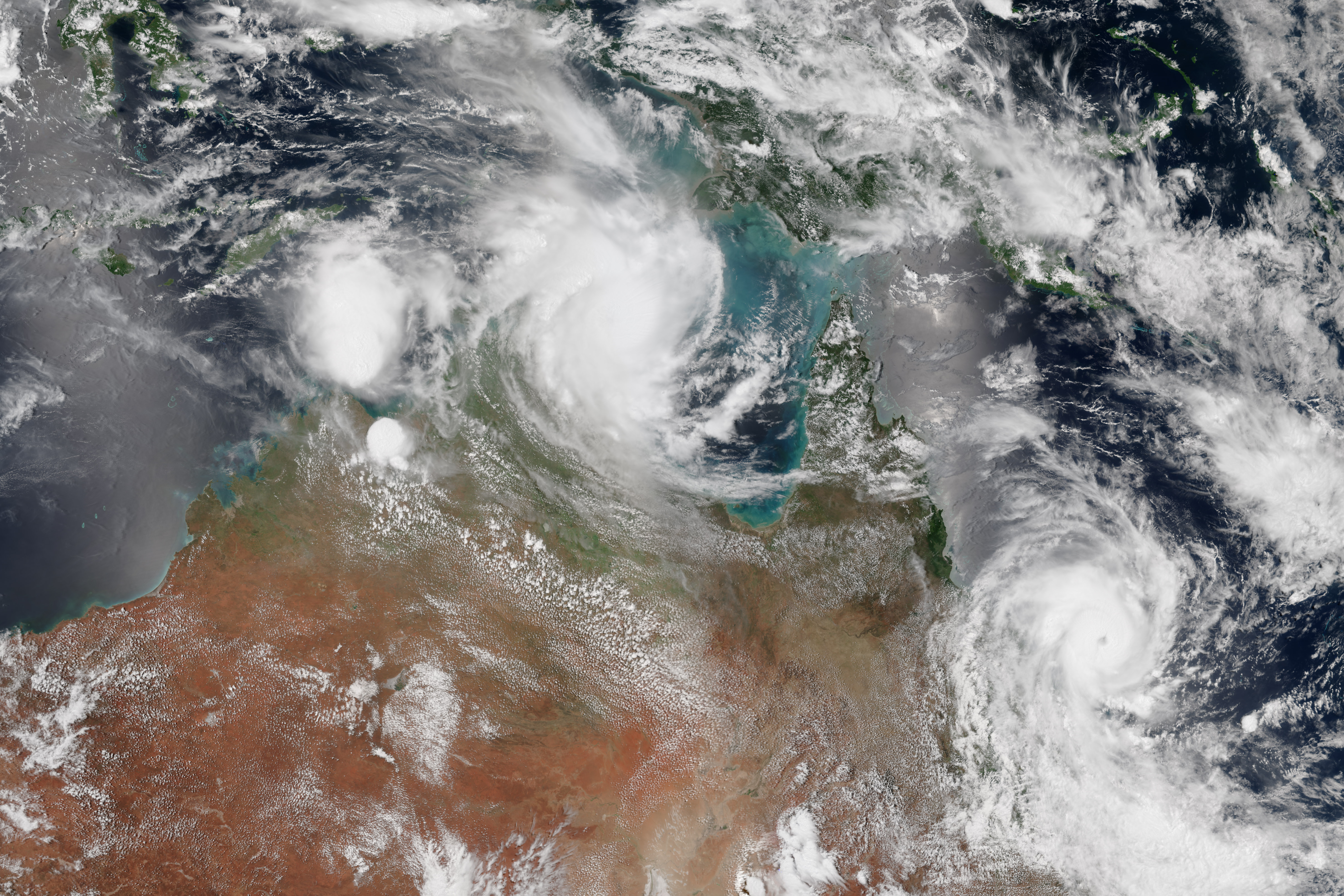
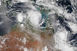
English: Northern Australia was battered by two potent tropical cyclones within six hours on the same day in February 2015. Cyclone Lam made landfall on the north-central coast near Milingimbi (about 400 kilometers east of Darwin) around 2 a.m. Australian central time on February 19. Cyclone Marcia made landfall on the east coast of Queensland near Rockhampton and Yeppoon around 8 a.m. local time on February 19.
At landfall, Lam had estimated wind speeds of approximately 165 kilometers (105 miles) per hour; Marcia came ashore with winds of 205 kilometers (125 miles) per hour. Marcia briefly reached category 5, only the sixth storm of that strength since records have been kept in Australia. According to meteorologist and blogger Jeff Masters, few major cyclones have made it so far south (around latitude 22°S) down the Australian coast. The Visible Infrared Imaging Radiometer Suite on the Suomi NPP satellite captured this view of the two storms around midday on February 19, 2015. The image is a composite of satellite data from two Suomi NPP passes over the area. As of February 20, no deaths had been reported from the storm, though damage assessments were still to be made in many of the remote towns. Water and power were lost in several areas hit by Lam. Power was knocked out by Marcia for at least 50,000 homes in Queensland.Deutsch: Der Norden Australiens wurde im Februar 2015 innerhalb von sechs Stunden von zwei kräftigen Zyklonen getroffen. Zyklon Lams Landfall ereignete sich an der zentralen Nordküste bei Milingimbi (etwa 400 km östlich von Darwin) am 19. Februar 2015 gegen 02:00 Uhr Ortszeit, und Zyklon Maria gelangte an der Ostküste Queensland in der Nähe von Rockhampton und Yeppon gegen 8:00 Uhr Ortszeit über das Festland.
Zum Zeitpunkt des Landfalls erreichte Lam Windgeschwindigkeiten von etwa 165 km/h; Marcia erreichte die Küste mit Windgeschwindigkeiten von 205 km/h Marcia erreicht kurzzeitig die Kategorie 5 und war erst der fünfte Sturm in dieser Kategorie seit Beginn der Aufzeichnungen in Australien. Nach den Angaben des Meteorologen und Bloggers Jeff Master sind nur wenige starke Zyklone so weit südlich (etwa 22° südlicher Breite) auf die australische Küste getroffen. Die Visible Infrared Imaging Radiometer Suite auf dem Suomi-NPP-Satellit zeichnete diese Ansicht der beiden Stürme gegen Mittag des 19. Februar 2015 auf. Das Bild ist aus den Satellitendaten von zwei Umläufen des Satelliten über dem Gebiet zusammengesetzt. Per 20. Februar wurde keine Todesopfer durch die Auswirkungen der beiden Stürmen gemeldet, obwohl die Schadensermittlungen in vielen der abgelegenen Städte noch nicht abgeschlossen waren. Wasser und Strom wurde in mehreren von Lam betroffenen Gebieten unterbrochen. Marcia unterbrach die Stromverbindung für mindestens 50.000 Haushalte in Queensland. |
| Date | |
| Source | http://earthobservatory.nasa.gov/IOTD/view.php?id=85335 |
| Author | Suomi NPP Satellite |
Licensing
| This file is in the public domain in the United States because it was solely created by NASA. NASA copyright policy states that "NASA material is not protected by copyright unless noted". (See Template:PD-USGov, NASA copyright policy page or JPL Image Use Policy.) | ||
 |
Warnings:
|
File history
Click on a date/time to view the file as it appeared at that time.
| Date/Time | Thumbnail | Dimensions | User | Comment | |
|---|---|---|---|---|---|
| current | 22:36, 23 February 2015 | | 5,914 × 3,943 (4.43 MB) | Hurricanehink | User created page with UploadWizard |
File usage
There are no pages that use this file.
Global file usage
The following other wikis use this file:
- Usage on en.wikipedia.org
- Usage on pt.wikipedia.org