
File:Extent of Siberian traps german.png
Size of this preview: 800 × 490 pixels. Other resolutions: 320 × 196 pixels | 640 × 392 pixels | 1,024 × 627 pixels | 1,280 × 784 pixels | 2,000 × 1,225 pixels.
Original file (2,000 × 1,225 pixels, file size: 3.28 MB, MIME type: image/png)
| This is a file from the Wikimedia Commons. Information from its description page there is shown below. Commons is a freely licensed media file repository. You can help. |
| Description |
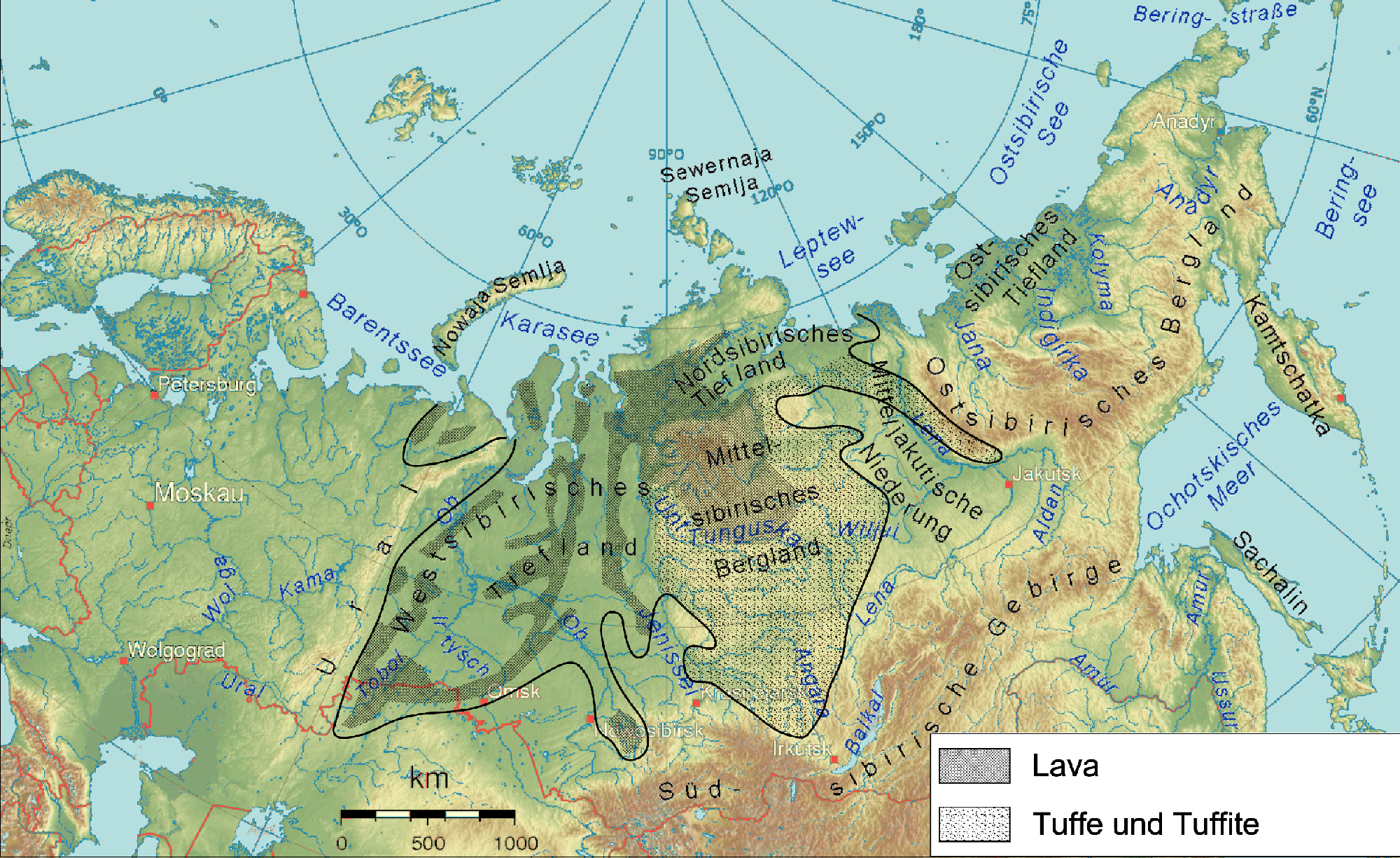
English: Physical map of Siberia with extent of Siberian traps according to http://www.mantleplumes.org/Siberia.html
Deutsch: Physische Karte von Sibirien mit der Verbreitung des Sibirischen Trapps (Quelle: http://www.mantleplumes.org/Siberia.html) |
| Date | (UTC) |
| Source | |
| Author |
|
| Other versions |
|

| This is a retouched picture, which means that it has been digitally altered from its original version. Modifications: Extent of Siberian traps according to http://www.mantleplumes.org/Siberia.html. The original can be viewed here: Sibirien topo2.png:
|

|
Permission is granted to copy, distribute and/or modify this document under the terms of the GNU Free Documentation License, Version 1.2 or any later version published by the Free Software Foundation; with no Invariant Sections, no Front-Cover Texts, and no Back-Cover Texts. A copy of the license is included in the section entitled GNU Free Documentation License. |
| This file is licensed under the Creative Commons Attribution-Share Alike 3.0 Unported license. | ||
| ||
| This licensing tag was added to this file as part of the GFDL licensing update. |
Original upload log
This image is a derivative work of the following images:
- Image:Sibirien_topo2.png licensed with GFDL-GMT
- 2008-04-20T17:37:12Z Ulamm 1590x973 (896288 Bytes)
- 2008-04-18T23:48:44Z Ulamm 1590x973 (892996 Bytes)
- 2008-04-18T21:06:01Z Ulamm 1590x973 (1198844 Bytes) {{Information |Description=Physical map of allmost all the Russian Federation emphasizing Siberia |Source=[[:Image:Russland topo.png]] |Date= |Author=~~~~ |Permission= |other_versions= |Information=The map has been created w
Uploaded with derivativeFX
File history
Click on a date/time to view the file as it appeared at that time.
| Date/Time | Thumbnail | Dimensions | User | Comment | |
|---|---|---|---|---|---|
| current | 20:30, 16 June 2008 | | 2,000 × 1,225 (3.28 MB) | Jo Weber | {{Information |Description={{en|Physical map of Siberia with extent of Siberian traps according to http://www.mantleplumes.org/Siberia.html}} {{de|Physische Karte von Sibirien mit der Verbreitung des Sibirischen Trapps (Quell |
File usage
The following page uses this file:
Global file usage
The following other wikis use this file:
- Usage on af.wikipedia.org
- Usage on ar.wikipedia.org
- Usage on ast.wikipedia.org
- Usage on bg.wikipedia.org
- Usage on cs.wikipedia.org
- Usage on da.wikipedia.org
- Usage on de.wikipedia.org
- Usage on en.wikipedia.org
- Usage on es.wikipedia.org
- Usage on eu.wikipedia.org
- Usage on fi.wikipedia.org
- Usage on fr.wikipedia.org
- Trapps de Sibérie
- Discussion:Trapps de Sibérie
- Utilisateur:Andrej Boris Collinsson/Images Sibérie 2
- Wikipédia:Statistiques des anecdotes de la page d'accueil/Visibilité des anecdotes (2020)
- Discussion:Trapps de Sibérie/LSV 18305
- Wikipédia:Statistiques des anecdotes de la page d'accueil/Visibilité des anecdotes (2020)/2020 06
- Projet:Aide et accueil/Twitter/Tweets/archives/juin 2020
- Wikipédia:Le saviez-vous ?/Archives/2020
- Usage on gl.wikipedia.org
- Usage on he.wikipedia.org
- Usage on hr.wikipedia.org
- Usage on id.wikipedia.org
- Usage on is.wikipedia.org
- Usage on ja.wikipedia.org
- Usage on ka.wikipedia.org
- Usage on ko.wikipedia.org
- Usage on nl.wikipedia.org
- Usage on no.wikipedia.org
- Usage on pl.wikipedia.org
- Usage on pt.wikipedia.org
- Usage on ru.wikipedia.org
- Usage on sh.wikipedia.org
- Usage on sl.wikipedia.org
- Usage on sv.wikipedia.org
- Usage on tr.wikipedia.org
- Usage on uk.wikipedia.org
- Usage on zh.wikipedia.org
View more global usage of this file.