
File:Grosse Ile Michigan aerial Jan2016.jpg

Size of this preview: 800 × 545 pixels. Other resolutions: 320 × 218 pixels | 640 × 436 pixels | 1,024 × 698 pixels | 1,280 × 872 pixels | 2,285 × 1,557 pixels.
Original file (2,285 × 1,557 pixels, file size: 1.91 MB, MIME type: image/jpeg)
| This is a file from the Wikimedia Commons. Information from its description page there is shown below. Commons is a freely licensed media file repository. You can help. |
Summary
| Description |
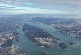
English: Aerial view of Grosse Ile in the Detroit River from the south, as viewed from an aircraft shortly after takeoff from Detroit Metropolitan Airport. Grosse Ile Municipal Airport can be seen at the southern end of the island. |
| Date | Taken on 7 January 2016 |
| Source | Own work |
| Author | Tim Kiser (TimK MSI) |
| Other versions |
.jpg)
| Camera location | | View this and other nearby images on: OpenStreetMap |
|---|
Licensing
I, the copyright holder of this work, hereby publish it under the following license:
This file is licensed under the Creative Commons Attribution-Share Alike 3.0 Unported license.
- You are free:
- to share – to copy, distribute and transmit the work
- to remix – to adapt the work
- Under the following conditions:
- attribution – You must give appropriate credit, provide a link to the license, and indicate if changes were made. You may do so in any reasonable manner, but not in any way that suggests the licensor endorses you or your use.
- share alike – If you remix, transform, or build upon the material, you must distribute your contributions under the same or compatible license as the original.
| Annotations | This image is annotated: View the annotations at Commons |
File history
Click on a date/time to view the file as it appeared at that time.
| Date/Time | Thumbnail | Dimensions | User | Comment | |
|---|---|---|---|---|---|
| current | 21:43, 23 April 2021 | | 2,285 × 1,557 (1.91 MB) | JPxG | Reverted to version as of 00:42, 1 February 2016 (UTC) Whoops. |
| 21:42, 23 April 2021 |  | 520 × 520 (189 KB) | JPxG | Cropped 77 % horizontally, 67 % vertically using CropTool with precise mode. | |
| 00:42, 1 February 2016 |  | 2,285 × 1,557 (1.91 MB) | TimK MSI | {{Information |Description ={{en|1=Aerial view of Grosse Ile in the Detroit River from the south, as viewed from an aircraft shortly after takeoff from Detroit Metropolitan Airport.}} |Source =... |
File usage
The following 2 pages use this file:
Global file usage
The following other wikis use this file:
- Usage on ar.wikipedia.org
- Usage on arz.wikipedia.org
- Usage on ceb.wikipedia.org
- Usage on cy.wikipedia.org
- Usage on en.wikipedia.org
- Usage on es.wikipedia.org
- Usage on eu.wikipedia.org
- Usage on fi.wikipedia.org
- Usage on fr.wikipedia.org
- Usage on no.wikipedia.org
- Usage on sr.wikipedia.org
- Usage on vi.wikipedia.org
- Usage on www.wikidata.org
- Usage on zh.wikipedia.org