
File:Charley 2004-08-13 1635Z.jpg

Size of this preview: 450 × 600 pixels. Other resolutions: 180 × 240 pixels | 360 × 480 pixels | 576 × 768 pixels | 768 × 1,024 pixels | 1,536 × 2,048 pixels | 4,800 × 6,400 pixels.
Original file (4,800 × 6,400 pixels, file size: 4.95 MB, MIME type: image/jpeg)
| This is a file from the Wikimedia Commons. Information from its description page there is shown below. Commons is a freely licensed media file repository. You can help. |
Summary
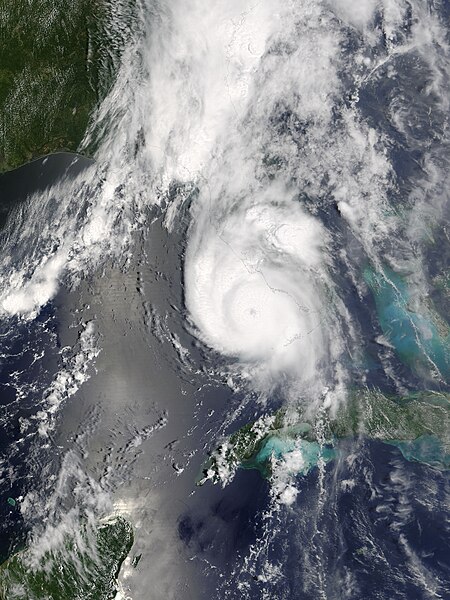
| Description | The MODIS sensor aboard NASA's Terra satellite captured this true-color image of Hurricane Charley on August 13 at 12:35 p.m. EDT. At the time this image was taken Charley was rapidly gaining strength and would reach category 4 status just 90 minutes later. Maximum sustained winds at 2:00 p.m. were at 145 mph and Charley was moving towards the north-northeast at 20 mph. | |||||
| Date | ||||||
| Source | http://earthobservatory.nasa.gov/NaturalHazards/natural_hazards_v2.php3?img_id=12331 | |||||
| Author | Image courtesy of the Space Science and Engineering Center, University of Wisconsin-Madison. | |||||
| Permission (Reusing this file) |
|
|||||
| Other versions | Image:Hurricane Charley 2004.jpg |

File history
Click on a date/time to view the file as it appeared at that time.
| Date/Time | Thumbnail | Dimensions | User | Comment | |
|---|---|---|---|---|---|
| current | 07:00, 8 November 2006 | | 4,800 × 6,400 (4.95 MB) | Good kitty | == Summary == {{Information |Description=The MODIS sensor aboard NASA's Terra satellite captured this true-color image of Hurricane Charley on August 13 at 12:35 p.m. EDT. At the time this image was taken Charley was rapidly gaining strength and would rea |
File usage
The following page uses this file:
Global file usage
The following other wikis use this file:
- Usage on ca.wikipedia.org
- Usage on en.wikipedia.org
- Everglades
- Wikipedia:Featured topics
- Portal:Tropical cyclones/Anniversaries/August
- Portal:Tropical cyclones/Anniversaries/August/13
- User:Sushant gupta/Ebox
- Wikipedia:Featured topics/Lists of Florida hurricanes
- Portal:Tropical cyclones/Featured article/List of Florida hurricanes
- User:TonyTheTiger/List of the Day/Nominees/200801
- Wikipedia:List of the day/January 2008
- Portal:Tropical cyclones/Featured article/List of Florida hurricanes (2000-present)
- User:Presidentman/potd/4 February 2013
- Usage on eo.wikipedia.org
- Usage on es.wikipedia.org
- Usage on fr.wikipedia.org
- Usage on hy.wikipedia.org
- Usage on ja.wikipedia.org
- Usage on pt.wikipedia.org
- Usage on ru.wikipedia.org
- Usage on th.wikipedia.org
- Usage on uk.wikipedia.org
- Usage on www.wikidata.org
- Usage on zh.wikipedia.org