
File:Hurricane Erika 2003 Radar.jpg
No higher resolution available.
Hurricane_Erika_2003_Radar.jpg (700 × 554 pixels, file size: 376 KB, MIME type: image/jpeg)
| This is a file from the Wikimedia Commons. Information from its description page there is shown below. Commons is a freely licensed media file repository. You can help. |
Summary
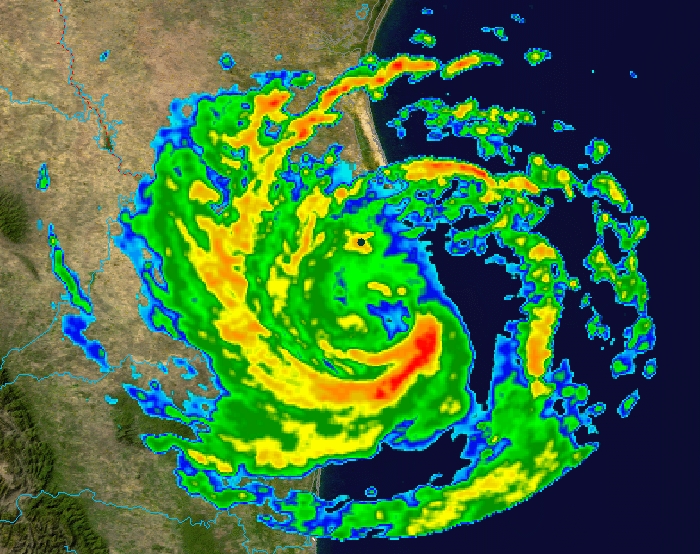
| Description | This image shows Hurricane Erika at 4:59 a.m. CDT on August 16, 2003, as it neared its landfall in Mexico. The foreground image is reflectivity data from the NWS NEXRAD radar at Brownsville, Texas; which is the black dot to the north of the center of the image. The background is true colour imagery derived from NASA's MODIS satellites. | ||
| Date | |||
| Source | Radar data from the NCDC NEXRAD database. Background image is NASA Blue Marble imagery. | ||
| Author | Composite created by Nilfanion. | ||
| Permission (Reusing this file) |
|
File history
Click on a date/time to view the file as it appeared at that time.
| Date/Time | Thumbnail | Dimensions | User | Comment | |
|---|---|---|---|---|---|
| current | 21:56, 16 October 2006 | | 700 × 554 (376 KB) | Nilfanion | {{Information |Description=This image shows Hurricane Erika at 4:59 a.m. CDT on August 16, 2003, as it neared its landfall in Mexico. The foreground image is reflectivity data from the NWS NEXRAD radar at Brownsville, Texas; which is the black dot to the |
File usage
The following page uses this file:
Global file usage
The following other wikis use this file:
- Usage on ca.wikipedia.org
- Usage on en.wikipedia.org
- Usage on eo.wikipedia.org
- Usage on es.wikipedia.org
- Usage on fi.wikipedia.org
- Usage on sv.wikipedia.org
- Usage on zh.wikipedia.org