
File:Interstate 35 Route.svg

Size of this PNG preview of this SVG file: 512 × 321 pixels. Other resolutions: 320 × 201 pixels | 640 × 401 pixels | 1,024 × 642 pixels | 1,280 × 803 pixels | 2,560 × 1,605 pixels.
Original file (SVG file, nominally 512 × 321 pixels, file size: 498 KB)
| This is a file from the Wikimedia Commons. Information from its description page there is shown below. Commons is a freely licensed media file repository. You can help. |
Summary
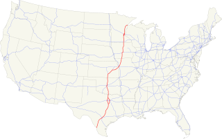
| Description |
|
|||
| Date | ||||
| Source | Own work based on: Map of current US Routes.svg by SPUI; data from <https://www.transportation.gov/> | |||
| Author |
|
|||
| SVG development | This map was created with Affinity Designer.
|


Licensing
I, the copyright holder of this work, hereby publish it under the following license:
| This file is made available under the Creative Commons CC0 1.0 Universal Public Domain Dedication. | |
| The person who associated a work with this deed has dedicated the work to the public domain by waiving all of their rights to the work worldwide under copyright law, including all related and neighboring rights, to the extent allowed by law. You can copy, modify, distribute and perform the work, even for commercial purposes, all without asking permission.
|
File history
Click on a date/time to view the file as it appeared at that time.
| Date/Time | Thumbnail | Dimensions | User | Comment | |
|---|---|---|---|---|---|
| current | 03:19, 26 June 2019 | | 512 × 321 (498 KB) | Pharexia | background color |
| 02:41, 26 June 2019 |  | 512 × 321 (497 KB) | Pharexia | User created page with UploadWizard |
File usage
There are no pages that use this file.
Global file usage
The following other wikis use this file:
- Usage on fa.wikipedia.org
- Usage on lmo.wikipedia.org
- Usage on th.wikipedia.org
- Usage on www.wikidata.org