
File:Isle of Man topographic map-en.svg

Size of this PNG preview of this SVG file: 654 × 600 pixels. Other resolutions: 262 × 240 pixels | 524 × 480 pixels | 838 × 768 pixels | 1,117 × 1,024 pixels | 2,234 × 2,048 pixels | 1,200 × 1,100 pixels.
Original file (SVG file, nominally 1,200 × 1,100 pixels, file size: 642 KB)
| This is a file from the Wikimedia Commons. Information from its description page there is shown below. Commons is a freely licensed media file repository. You can help. |

Summary
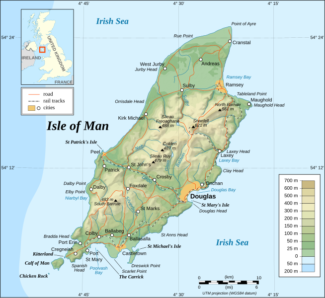
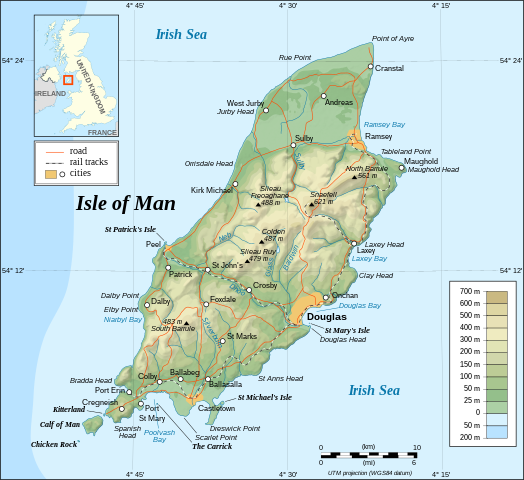
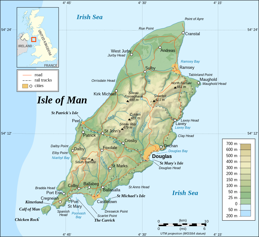
This image was selected as picture of the day on Wikimedia Commons for 26 November 2008. It was captioned as follows: English: Topographic map of the Isle of Man. Other languages:
Čeština: Topografická mapa Ostrova Man Dansk: Topografisk kort over Isle of Man. English: Topographic map of the Isle of Man. Français : Carte topographique en anglais de l'Île de Man. Íslenska: Staðfræðikort af eynni Mön. Italiano: Mappa topografica dell'Isola di Man. Magyar: Man sziget domborzati térképe Nederlands: Engelstalige topografische kaart van het Britse eiland Man Português: Mapa topográfico (em Inglês) da Ilha de Man. Română: Hartă topografică a Insulei Man Suomi: Mansaaren topografinen kartta. Svenska: Topografisk karta över Isle of Man. Русский: Топографическая карта Острова Мэн. 中文: 马恩岛地形图 中文(繁體): 曼島地形圖 |
|

| Description |
English: Topographic map in English of the Isle of Man.
Note : The shaded relief is a raster image embedded in the SVG. Français : Carte topographique en anglais de l'Île de Man.
Note : Le relief ombré est une image bitmap embarquée dans le fichier SVG. Português: Mapa topográfico (em Inglês) da Ilha de Man.
Русский: Топографическая карта Острова Мэн на английском языке UTM projection; WGS84 datum; shaded relief (composite image of N-W, W and N lightning positions); |
||
| Date | |||
| Source |
Own work ;
|
||
| Author | Eric Gaba (Sting - fr:Sting) | ||
| Permission (Reusing this file) |
|
||
| Other versions |
Derivative works of this file: Isle of Man topographic map-ca.svg
[]
|


|
This SVG file contains embedded text that can be translated into your language, using any capable SVG editor, text editor or the SVG Translate tool. For more information see: About translating SVG files. |
Licensing
I, the copyright holder of this work, hereby publish it under the following licenses:

|
Permission is granted to copy, distribute and/or modify this document under the terms of the GNU Free Documentation License, Version 1.2 or any later version published by the Free Software Foundation; with no Invariant Sections, no Front-Cover Texts, and no Back-Cover Texts. A copy of the license is included in the section entitled GNU Free Documentation License. |
| This file is licensed under the Creative Commons Attribution-Share Alike 3.0 Unported license. | ||
| ||
| This licensing tag was added to this file as part of the GFDL licensing update. |
This file is licensed under the Creative Commons Attribution-Share Alike 2.5 Generic, 2.0 Generic and 1.0 Generic license.
- You are free:
- to share – to copy, distribute and transmit the work
- to remix – to adapt the work
- Under the following conditions:
- attribution – You must give appropriate credit, provide a link to the license, and indicate if changes were made. You may do so in any reasonable manner, but not in any way that suggests the licensor endorses you or your use.
- share alike – If you remix, transform, or build upon the material, you must distribute your contributions under the same or compatible license as the original.
You may select the license of your choice.
File history
Click on a date/time to view the file as it appeared at that time.
| Date/Time | Thumbnail | Dimensions | User | Comment | |
|---|---|---|---|---|---|
| current | 13:40, 4 September 2008 | | 1,200 × 1,100 (642 KB) | Sting | New standard colors |
| 23:19, 29 October 2007 |  | 1,200 × 1,100 (745 KB) | Sting | Some additional informations | |
| 20:55, 21 May 2007 |  | 1,200 × 1,100 (742 KB) | Sting | Some correction | |
| 18:24, 21 May 2007 |  | 1,200 × 1,100 (742 KB) | Sting | {{Information |Description=Topographic map in English of the Isle of Man |Source=Own work ;<br/>Topographic map : [http://www2.jpl.nasa.gov/srtm NASA Shuttle Radar Topography Mission] (SRTM3 v.2) (public domain) edited with [http://www |
File usage
The following page uses this file:
Global file usage
The following other wikis use this file:
- Usage on af.wikipedia.org
- Usage on bn.wikipedia.org
- Usage on cs.wikipedia.org
- Usage on da.wikipedia.org
- Usage on de.wikipedia.org
- Usage on en.wikipedia.org
- Usage on fi.wikipedia.org
- Usage on fr.wikipedia.org
- Usage on gv.wikipedia.org
- Usage on hu.wikipedia.org
- Usage on ko.wikipedia.org
- Usage on nl.wikipedia.org
- Usage on pl.wikipedia.org
- Usage on pt.wikipedia.org
- Usage on sc.wikipedia.org
- Usage on sk.wikipedia.org
- Usage on sv.wikipedia.org
- Usage on tr.wikipedia.org
- Usage on uk.wikipedia.org
- Usage on www.wikidata.org
- Usage on zh.wikipedia.org