
File:Istakhri map 2.jpg

Size of this preview: 549 × 600 pixels. Other resolutions: 220 × 240 pixels | 550 × 601 pixels.
Original file (550 × 601 pixels, file size: 259 KB, MIME type: image/jpeg)
| This is a file from the Wikimedia Commons. Information from its description page there is shown below. Commons is a freely licensed media file repository. You can help. |
Summary
| Description |
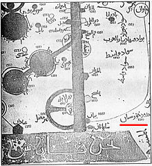
English: 9th century map showing Khuzestan. Map was extracted (scanned) by Zereshk, from copy of "Al-aqaleem" by Istakhri, re-print of 1839, located at Iran National Museum's Library.
|
|||||||||||||||||||||||
| Date | 7 June 2005 (original upload date) | |||||||||||||||||||||||
| Source | Zereshk, from copy of "Al-aqaleem" by Istakhri, re-print of 1839, located at Iran National Museum's Library. Originally from en.wikipedia; description page is/was here. | |||||||||||||||||||||||
| Author |
|
|||||||||||||||||||||||
| Permission (Reusing this file) |
Released under the GNU Free Documentation License. | |||||||||||||||||||||||

Licensing

|
Permission is granted to copy, distribute and/or modify this document under the terms of the GNU Free Documentation License, Version 1.2 or any later version published by the Free Software Foundation; with no Invariant Sections, no Front-Cover Texts, and no Back-Cover Texts. A copy of the license is included in the section entitled GNU Free Documentation License. |
| This file is licensed under the Creative Commons Attribution-Share Alike 3.0 Unported license. | ||
| ||
| This licensing tag was added to this file as part of the GFDL licensing update. |
Original upload log
(All user names refer to en.wikipedia)
- 2005-06-07 07:29 Zereshk 550×601×8 (265360 bytes) 9th century map showing Khuzestan. Map was extracted (scanned) by Zereshk, from copy of "Al-aqaleem" by Istakhri, re-print of 1839, located at Iran National Museum's Library. {{GFDL}}
File history
Click on a date/time to view the file as it appeared at that time.
| Date/Time | Thumbnail | Dimensions | User | Comment | |
|---|---|---|---|---|---|
| current | 22:14, 18 March 2007 | | 550 × 601 (259 KB) | Angusmclellan | {{Information |Description=9th century map showing Khuzestan. Map was extracted (scanned) by Zereshk, from copy of "Al-aqaleem" by Istakhri, re-print of 1839, located at Iran National Museum's Library. |Source=Originally from [http://en.wikipedia.org en.w |
File usage
The following page uses this file:
Global file usage
The following other wikis use this file:
- Usage on ar.wikipedia.org
- Usage on arz.wikipedia.org
- Usage on az.wikipedia.org
- Usage on de.wikipedia.org
- Usage on diq.wikipedia.org
- Usage on en.wikipedia.org
- Usage on es.wikipedia.org
- Usage on et.wikipedia.org
- Usage on fa.wikipedia.org
- Usage on fa.wikibooks.org
- Usage on fr.wikipedia.org
- Usage on hi.wikipedia.org
- Usage on hr.wikipedia.org
- Usage on it.wikipedia.org
- Usage on ja.wikipedia.org
- Usage on ko.wikipedia.org
- Usage on mzn.wikipedia.org
- Usage on pnb.wikipedia.org
- Usage on ro.wikipedia.org
- Usage on ru.wikipedia.org
- Usage on sh.wikipedia.org
- Usage on sv.wikipedia.org
- Usage on tr.wikipedia.org
- Usage on uk.wikipedia.org
- Usage on ur.wikipedia.org
- Usage on zh.wikipedia.org